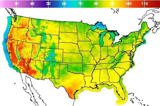
Aug. 2 (UPI) — People on the West Coast are bracing to sweat out triple-digit weather conditions this week.
Coastal Washington, Oregon and Northern California should expect “the hottest and longest period of very hot weather in some years,” the National Weather Service said in a warning Monday.
The excessive heat warnings are in effect across the region through Friday.
“Overall, expect humid and hot conditions to continue through much of the week,” the weather service said. “There will be little relief from the heat overnight [Monday] away from the coast through much of the week.”
Medford, Ore., hit 102 degrees Monday — and is expected to climb a forecast high of 114 on Wednesday.
Forecasters in Portland said high temperatures on Thursday would likely top the city’s all-time record of 107 degrees. Portland has only seen three consecutive days of triple-digit temperatures seven times in the last 77 years — the most recent coming in August 1981.
Temperatures could approach a 2009 record of 103 degrees in Seattle, which has had triple-digit temperatures only three times in July.
Reno, Nev., might break break the record for most 100-degree days in a year — 12 set in 2013, the weather service in Reno said. So far, it has had nine. It reached on 100 on Monday.
In Redding, Calif., the NWC said “there is even a non-zero chance of reaching the all-time record high of 118” on Tuesday or Wednesday. That’s 21 degrees higher than the city’s August average.
In California’s Antelope Valley, temperatures are forecast to hit as high as 103 in the Santa Clarita Valley.
“This is a dangerous situation, with an increased threat of life- threatening heat-related illness,” the NWS in Los Angeles said in an advisory.
The NWS in Hanford — in California’s central San Joaquin Valley — posted on Twitter: “Hot week ahead. Stay safe wherever you are! #HeatSafety.”
A ridge of high pressure is pushing the cool Pacific jet stream north into Canada, which allows midsummer heat to move north from the desert Southwest, forecasters said — and it’s clearing out any cloud cover that could block the sun’s rays.


