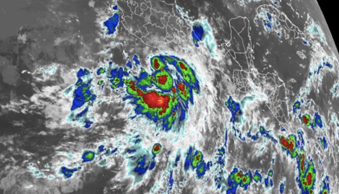
June 25, 2021 (Gephardt Daily) — While Atlantic tropical activity has diminished to a slight simmer for the time being after Claudette’s tour of the southeastern United States, waters over the eastern Pacific have spawned Tropical Storm Enrique. AccuWeather meteorologists predict Enrique will become the first hurricane of the 2021 season for either basin.
Enrique was upgraded to a tropical storm and the fifth named system in the eastern Pacific basin early Friday morning and further strengthening is anticipated into this weekend. As of 4 p.m. CDT Friday, Enrique had maximum sustained winds of 50 mph with higher gusts and was moving toward the west-northwest at 8 mph.
The eye of the storm was situated 225 miles south-southeast of Manzanillo, Mexico, and 350 miles south-southeast of Cabo Corrientes, Mexico.
The tropical cyclone will continue to move in a general west to northwest motion into next week and reside in an environment conducive for strengthening in the short-term, AccuWeather senior meteorologist Rob Miller said.
The northwest path will take the system over warm water and low wind shear. Tropical cyclones need warm water to allow towering thunderstorms to form. This rising air causes barometric pressure to fall. As air rushes in from the sides, the mass of storms around a system begins to spin faster and faster.
Wind shear is the sudden increase or change in direction of breezes at different levels of the atmosphere and across the horizontal part of the atmosphere. Even though some storms can strengthen despite strong wind shear, most struggle to develop or maintain strength. Weaker wind shear, on the other hand, can enable a storm to become better organized.
“Enrique should be able to strengthen into a Category 1 hurricane, with maximum sustained winds of 74-95 mph, over the weekend,” Miller said. After that, the system could reach cooler waters that cause a reduction in wind intensity early next week.
“While most of the impacts from Enrique will remain offshore and over the open waters of the eastern Pacific, outer rain bands will brush the southwestern coast of Mexico into early next week and raise the risk of flash flooding,” Miller added.
Areas that have the greatest risk of localized flooding downpours and mudslides will extend from Acapulco to Puerto Vallarta, Mexico. Part of this area was hit with up to 15.75 inches of rain and gusty winds from Tropical Storm Dolores last week. Dolores formed on June 18 and dissipated after moving inland on June 20 near the Michoacán and Colima state border of Mexico.
Rainfall totals of 4-8 inches with an AccuWeather Local StormMax&trade of 15 inches can occur.
“Dangerous surf will also impact coastal areas of southwest Mexico into next week,” Miller said.
Otherwise, a few gusts to near 60 mph can occur along the immediate coast, which is strong enough to break tree limbs and potentially trigger sporadic power outages.
There is a small chance that some moisture may be drawn far enough to the north to make it into part of the southwestern United States later next week. However, if Enrique were to break up before approaching the tip of Baja California, Mexico, that potential would diminish.
AccuWeather meteorologists are predicting 14-18 named storms in the eastern Pacific this season with six to 10 expected to become hurricanes.
Atlantic enters quiet tropical period
Waters over the Atlantic basin have grown quiet for the most part.
There is a tropical disturbance, called a tropical wave, that moved westward off the coast of Africa at midweek. As AccuWeather meteorologists will continue to monitor and track this feature as it drifts along to the west, they say conditions are not immediately conducive for development in the short term.
“Some dry air, cool water and moderate wind shear exist in the path of this disturbance and will likely prevent development from occurring into this weekend,” Miller said.
The feature currently has a low risk of developing into a tropical depression or storm over the next five days.
“Some time early next week, wind shear is forecast to ease up along the systems’s path to the west-northwest and may allow for some gradual development to occur,” Miller added.
However, ocean water temperatures may still be too cool to allow much organization and development next week.
Should the feature hold together, it is likely to pass through the Lesser Antilles around the middle of next week and may produce locally heavy rainfall and gusty winds.
Farther to the west, a broad area of disturbed weather known for producing clusters of showers and thunderstorms this time of the year is likely to linger near Central America and southern Mexico. This broad area of low barometric pressure, known as a gyre, can be a source for gradual tropical development this time of the year.
It was in waters over the western Gulf where Claudette had its beginnings last week as a Potential Tropical Cyclone. Claudette was not officially named a tropical storm until it moved over land in southeastern Louisiana early Saturday. As weak as Claudette was, it took the lives of at least 14 people in the U.S.
Tropical Storm Ana formed and dissipated over waters off the central Atlantic, near Bermuda, in mid-May. Tropical Storm Bill developed and diminished in waters just off the Atlantic coast during mid-June.
AccuWeather meteorologists are predicting an above-average Atlantic hurricane season with 16-20 named storms, of which seven to 10 are forecast to become hurricanes. Thus far in 2021 there have been three tropical storms in the Atlantic basin.


