SALT LAKE CITY, Utah, Dec. 26, 2024 (Gephardt Daily) — Another round of winter weather is making its way into Utah, with rain and snow expected in waves starting Thursday morning.
According to a Utah Department of Transportation road weather alert, the first wave will arrive along the Wasatch Front between 8 and 9 a.m., before making its way south.
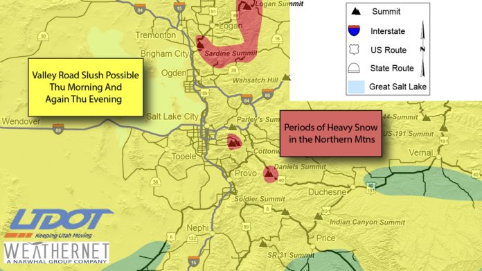
“With temperatures around freezing Thursday morning, some minor road snow can’t be ruled out across the Wasatch Front with most occurring in Weber and Davis counties where up to an inch or two will be possible,” UDOT says.
“By 10-11 a.m., Wasatch Front routes are expected to run wet. The Wasatch Back and mountain routes are looking at a few inches of road snow, mainly through noon, with some briefly heavy road snow possible over the upper Cottonwoods as well as Logan Summit.”
Sardine Summit and Daniels Summit may also see some briefly heavy snowfall.
UDOT says Central Utah valley routes may see a lighter layer of road snow, with an inch or two possible in the mountains.
The snow should last until about noon before tapering off, with a second wave of snow and rain moving in around 4 to 6 p.m
“With temperatures a bit warmer at this point, the Wasatch Front will likely see more of a rain/snow mix. However, some showers may be briefly heavy for short periods of time and be enough to slush up the roads late afternoon/evening with bench routes seeing the higher concern.
“The northern mountain/Wasatch Back routes are expected to see a quick couple inches of snow during this time as well,” UDOT says.
“All snowfall is expected to end around 9 p.m. for the Wasatch Front/valleys and around midnight for the mountains. Portions of Central Utah may see some snow in the evening as well from this second wave, but likely just looking at very minor amounts.”
Motorists are advised to use caution and TravelWise.
“Motorists using canyon and mountain routes should be aware Traction Laws may be enforced,” UDOT advises.
The following routes will experience weather-related travel concerns during the forecast period:
- I-15, ID border through the Wasatch Front to Cove Fort
- I-80, Entire route
- I-84, Entire route
- I-215, Entire route
- I-70, I-15 Jct over Clear Creek Summit; Salina Summit
- US-40, I-80 Jct to Duchesne; Vernal to CO border
- US-189, Provo Canyon
- US-6, Over Kings Canyon; Spanish Fork over Soldiers Summit to Price
- US-89, ID border to Manti
- US-50, Over the summit
- US-191, WY border to Vernal; over Indian Canyon Summit
- SR-190, Big Cottonwood Canyon
- SR-210, Little Cottonwood Canyon
- SR-35, Entire route
- SR-31, Skyline Drive
- SR-20, Summit
- SR-153, Summit
- SR-143, Near Brian Head
- SR-14, Summit


