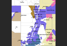
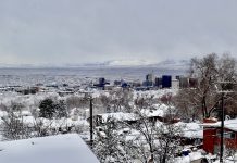
SALT LAKE CITY, Utah, Feb. 14, 2023 (Gephardt Daily) — Although March is closer than ever, the National Weather Service is forecasting another swat from winter Tuesday and Wednesday.
A winter storm will begin in the dark, starting early Tuesday, becoming widespread over central and southern Utah by Tuesday afternoon, the NWS said.
Expect 3-5 inches of snow in the valleys and up to 12 inches in the mountains
Prepare for winter driving with low visibility in heavy and/or blowing snow, plus traction restrictions on mountain roads.
Although the snowfall should taper off Wednesday, the NWS said temperatures will continue to drop that day.
Watch for lows of 10 to 15 degrees below zero in Cache Valley, as low as five degrees in the Zion Canyon National Park area, and the worst of it in the Bryce Canyon National Park area — 30 to 35 degrees below zero.
In such extremes, the NWS advises covering all exposed skin, limiting time outdoors, and barring that, packing an emergency kit.
Check for current conditions at weather.gov/slc.


