UTAH, Jan. 6, 2018 (Gephardt Daily) — The Utah Avalanche Center tweeted Sunday the current danger rating for northern Utah is considerable, and that is likely to raise to high later Sunday.
“Rising avalanche hazard, reaching HIGH later Sunday and into Monday,” the tweet said. “Winds and storm snow will create unstable conditions, including low elevations.”
The danger rating scale has five levels: low, moderate, considerable, high and extreme.
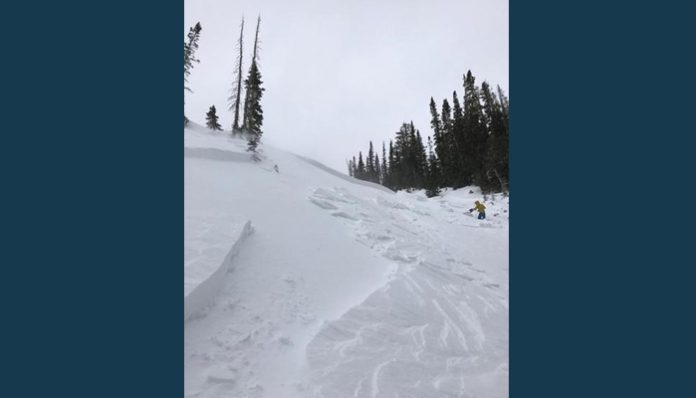
The UAC website said: “There were eight human-triggered avalanches reported from the back country on Saturday.These were all hard wind slabs, 6 inches to 24 inches thick and 25 feet to 200 feet wide. Some ran up to 350 feet vertical. In four of the slides, at least one member of the party went for a ride, with injuries involved in two of the occurrences. These hard wind slabs were on slopes facing north, northeast, and east, aspects what we refer to as leeward as they were drifted from the windward south, southwest, and westerly winds. However, one slide was on a west aspect, indicating how terrain can channel winds and deposit fresh drifts on almost any aspect. These slides were all in large, open, exposed terrain, and generally above 9500 feet.”
The National Weather Service and local agencies are cautioning everyone to be extremely careful while driving also because of the possibility of heavy snow and hazardous roads in most areas of the state through Sunday.
NWS has a winter weather advisory for the Central and Southwest Mountains, Wasatch Plateau/Book Cliffs, and Southern Utah Mountains.
Snow is expected with accumulations of 2 to 6 inches in the Wasatch Plateau/Book Cliffs, Central Mountains and Southern Mountains until 5 p.m. Sunday.
For the Wasatch Mountains I-80 North, Western Uinta Mountains, and Wasatch Mountains South of I-80, the National Weather Service advisory says snow accumulations of 4 to 9 inches are expected until 5 p.m. Sunday.
It’s safe to say that anyone who is driving in Utah through Sunday evening should use extreme caution and be ready for an icy glaze and build-up of snow on the roadways.
For more NWS information and updates, click here.

