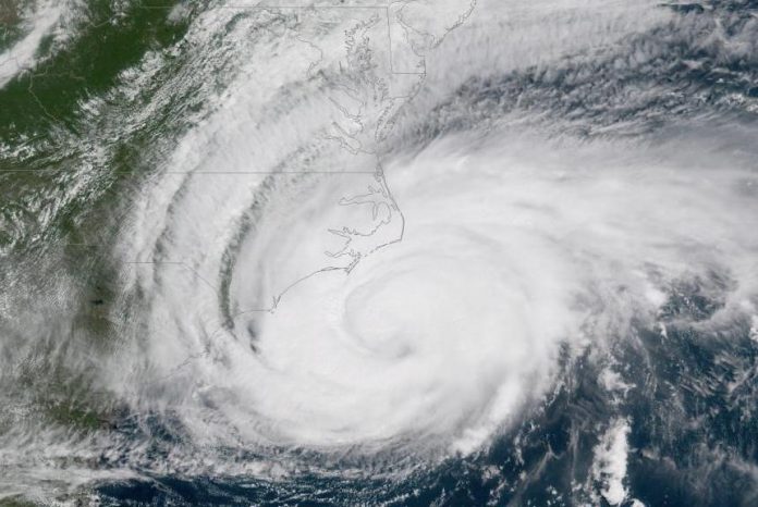
Sept. 14 (UPI) — Hurricane Florence slowed as it approached land Thursday afternoon, making catastrophic flooding more of a threat for the Carolina coast, the National Hurricane Center said.
The Category 2 storm was moving northwest at 6 mph, the NHC said in its 11 p.m. EDT update. At 2 p.m., the storm was moving northwest at 10 mph. The center of the storm was about 50 miles south Morehead City, N.C., and 60 miles east-southeast of Wilmington, N.C., and had 90 mph maximum sustained winds.
Though the storm has weakened as it approached land, its biggest threat was expected to be heavy rainfall and storm surges.
“Life-threatening, catastrophic flash flooding and prolonged significant river flooding are likely over portions of the Carolinas and the southern and central Appalachians through early next week, as Florence is expected to slow down as it approaches the coast and moves inland,” the NHC said.
Meteorological models project up to 40 inches of rain for parts of North and South Carolina through Sunday before the hurricane disperses.
The all-time mark for three-day rainfall for Wilmington, N.C., a city n the hurricane’s projected path, is nearly 20 inches, set in 2010.
Forecasters said Florence is expected to produce total rainfall accumulations of 20 inches to 30 inches along the North Carolina coast — and possibly 40 inches in some spots. Up to 15 inches could fall in parts of coastal South Carolina.
Storm surges of 13 feet and widespread power failures also were expected, and more than a million people had evacuated the areas most under threat.
“Florence will approach the coasts of North and South Carolina later [Thursday], then move near or over the coast of southern North Carolina and eastern South Carolina in the hurricane warning area [Thursday] and Friday,” the NHC said Thursday. “A slow motion over eastern South Carolina is forecast Friday night through Saturday night.”
Hurricane-force winds extend 80 miles from the storm’s center and tropical-storm-force winds extend outward 195 miles.
A hurricane warning was in effect from the South Santee River, S.C., to Duck, N.C., and in the Albemarle and Pamlico Sounds. A hurricane watch was issued for Edisto Beach, S.C., to the South Santee River.
A tropical storm warning, indicating the expectation of conditions below hurricane-strength winds, covered the Virginia-North Carolina border to Duck, N.C., and south of Chesapeake Bay, and from south of South Santee River to Edisto Beach, S.C.
A storm surge warning, anticipating life-threatening inundation of rising water on the coast within the next 36 hours, was in effect for the South Santee River, S.C., to Duck, N.C., including the Neuse and Pamlico Rivers at the Abemarle and Pamlico Sounds.


