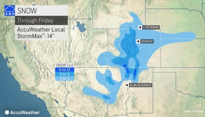
A storm already triggering much-needed rain and mountain snow over extremely parched parts of the Southwest will move along a 2,500-mile-long stretch of the United States and Canada.
And while it isn’t expected to become a powerhouse storm, the system will have far-reaching effects across the Rockies, portions of the Plains, Midwest and eastern Canada, as it unleashes accumulating snow and causes difficult travel along its long track.
The heaviest snowfall from the storm is predicted in parts of Ontario and Quebec on Saturday and Sunday. And even though the storm is not expected to shut down travel along its path totally for the United States on Friday and Saturday, enough snow to shovel, plow and make roads slippery is anticipated from Colorado to parts of Kansas, Nebraska, Iowa, Missouri, Illinois, Wisconsin and Michigan.
Forecasters said that motorists should expect delays due to slippery roads along stretches of Interstate 25, I-29, I-35, I-70, I-75, I-80, I-88, I-90 and I-94.
Snow will spread northward over much of Colorado during Thursday night and continue into Friday. For some areas in this zone, it will be a dramatic weather roller coaster this week. The high reached an “amazing” 68 F on Wednesday — only three degrees shy of the daily record high of 71 set way back in 1957, according to the National Weather Service, but the high will only reach in the upper 20s with snow falling on Friday.
An AccuWeather Local StormMax&trade snowfall of 14 inches is forecast for the high country over parts of the Colorado Rockies and San Juan Mountains farther to the south.
Farther to the east, the storm is likely to bring rain at the onset from the central Plains to the Great Lakes region on Friday and Friday night. However, precipitation will switch over to snow as colder air invades the storm as it moves along to the northeast Friday night into Saturday.
People out running errands or shopping on Saturday should be aware of changing weather conditions even though the day may start mild and wet from eastern Iowa and northern Illinois to southern Wisconsin.
Cities that will pick up enough snow to make roads slippery include Colorado Springs, Colo., Topeka, Kan., Kansas City, Mo., Chicago and Lansing, Mich.
A few inches of snow are forecast for Denver, Des Moines, Iowa, Omaha, Neb. and Madison, Wis.
“A gradation of snow accumulation is likely in the Chicago and Milwaukee metro areas with snowfall increasing away from the relatively warm shores of Lake Michigan, where both downtown areas reside,” AccuWeather senior meteorologist Joe Lundberg said.
The distant northwestern suburbs of Chicago and the southwestern suburbs of Milwaukee are likely to receive several inches of snow.
“Road conditions may deteriorate and turn slippery as the afternoon and evening hours of Saturday progress around Chicago,” Lundberg said.
Even though the downtown area of Chicago is forecast to receive about an inch of snow, a southeastward shift in the storm track by as little as 25 miles could put the stripe of 3- to 6-inch snowfall right in the city, instead of across the distant northern and western suburbs.
Chicago’s O’Hare Airport hasn’t picked up an inch of snow or greater since 3 inches of snow fell back on April 17. Only 0.7 of an inch has fallen at the official reporting site for the city since autumn began, and it occurred just a couple of days prior to Thanksgiving on Nov. 24. Since the official start of fall, Chicago has observed only about a quarter of the snowfall it typically gets to date.
Rockford, Ill., as well as Muskegon, Mount Pleasant and Traverse City, Mich., are in line to get a thumping of hefty snow from the storm.
Detroit is not forecast to receive much snow at all from the storm, but the heaviest snowfall of 6-12 inches is expected across areas farther to the north across the northern part of the Lower Peninsula of Michigan. Even without this storm, Detroit is well ahead of seasonal snowfall, when compared to Chicago, with 6 inches thus far.
A few locations in the northern part of the Lower Peninsula of Michigan may also pick up the AccuWeather Local StormMax&trade of 18 inches.
Across the border in Canada, places like Sudbury, Ontario, could also be buried under 6-12 inches of snow, with an AccuWeather Local StormMax&trade of 18 inches anticipated over the central parts of Ontario and Quebec, according to AccuWeather senior meteorologist Brett Anderson.
But, a different form of wintry precipitation will cause trouble in other areas farther to the south, where temperature profiles in the atmosphere will be a bit more complicated. Cold air may linger at the surface as mild air rides up and over a zone across southern Canada.
“We also expect a narrow zone of freezing rain or an icy mix to be centered on part of the St. Lawrence Valley, including the Montreal area,” AccuWeather senior meteorologist John Feerick said.
Closer toward the Gulf of St. Lawrence, heavy snow is in store for some of the Eastern Townships of Quebec, northern New Brunswick and even northern Maine.
On the storm’s warm side, over the Southern and Eastern states, showers are in the offing for at least part of the weekend. However, that may not be the most problematic weather factor for motorists and airline passengers. Patchy fog may develop and lower visibility as warm and moist air flows over the chilled ground in Detroit, Pittsburgh, New York City, Boston, Philadelphia, Atlanta and Charlotte, N.C.
In the wake of this big storm, another sneaky storm is forecast to drop snow from Colorado to parts of Oklahoma later this weekend. However, the punches from Old Man Winter may not stop there as AccuWeather meteorologists are also watching a potential snowstorm for the interior mid-Atlantic and New England states during next Wednesday to Thursday. The rain/snow line could be very close to the major cities of Washington, D.C., Baltimore, Philadelphia and New York City.


