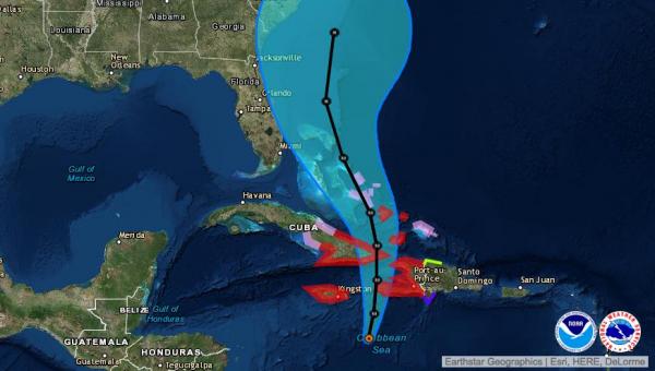
MIAMI, Oct. 3 (UPI) — Forecasters are urging residents in Haiti, Cuba and the Bahamas to rush final preparations to completion as a slow-moving and very dangerous Hurricane Matthew approaches, packing 140 mph winds, torrential rainfall of up to 40 inches and storm surge up to 15 feet.
Two fishermen were reported killed in Haiti early Monday, where residents are least prepared for a disastrous storm like Matthew.
The National Hurricane Center in Miami reports Matthew’s center will approach southwestern Haiti Monday night, extreme eastern Cuba late Tuesday and the Bahamas on Wednesday.
Torrential rains began in southern Haiti and the Dominican Republic Sunday night. Those areas will bear the brunt of Matthew’s strength. Thousands of Haitians live in ramshackle homes that will not stand up to the storm’s winds, and about 55,000 people still live in tents after previous storms and earthquakes.
Fluctuations in strength are expected but the storm is expected to remain a “major” hurricane through at least Wednesday. Florida’s Atlantic coast remains in Matthew’s “cone of uncertainty,” though current computer model consensus keeps it offshore. Dangerous surf conditions will occur there regardless.
Hurricane warnings are in effect for Jamaica, Haiti and Cuba’s Guantanamo, Santiago de Cuba, Holguin, Granma and Las Tunas provinces. The U.S. government began evacuation preparations to airlift hundreds of people out of the Guantanamo Bay detention center ahead of the storm.
The NHC warns that people living under hurricane or tropical storm advisories should make preparations as soon as possible because tropical storm conditions will begin in Jamaica, Haiti and the Dominican Republic within hours.
“Preparations to protect life and property should be rushed to completion,” the NHCsaid in a statement.
Officials in South Florida began early preparations for hurricane conditions, with emergency operations in Palm Beach County increased to “enhanced monitoring.” Matthew is expected to be near Florida Thursday and Friday.
“This is a major storm and all it takes is a little wobble to the west and we could have the potential of a potent hurricane on our doorstep,” said emergency center director Bill Johnson told the Palm Beach Post.
Florida’s Atlantic coast currently has up to a 40 percent chance of seeing tropical storm-force winds under Matthew’s current track. No warnings or watches are in effect there.
Matthew remains a Category 4 storm moving north at a very slow speed of 6 mph. Although it is expected to pick up speed beginning Monday, its very slow movement means areas under current hurricane warnings will face extended periods of destructive winds and flooding rains.
“Life-threatening flash floods and mudslides are likely from this rainfall in southern and northwestern Haiti, the southwestern Dominican Republic, and eastern Cuba,” the NHC added.
An Air Force Reserve Hurricane Hunter recorded hurricane-force winds extending 35 miles out from Matthew’s eye, with tropical storm-force winds extending out up to 185 miles. The storm passed over a NOAA ocean buoy early Monday morning, recording wave heights of 34 feet at 11:50 p.m. Sunday.
Matthew’s storm surge – the ocean level beyond normal tides, one of the most destructive elements of a hurricane – is forecast to range from up to 11 feet in eastern Cuba and southern Haiti to 4 feet in Jamaica. Storm surge in the central and southeastern Bahamas could reach as high as 15 feet.
Heavy rains are particularly troublesome for Haiti, where deforestation has left the region ripe for severe mudslides.
Matthew is expected to weaken slightly as it passes over the Greater Antilles, but is likely to remain a dangerous “major” hurricane with winds of 120 mph after emerging over the Bahamas.
“Although the official forecast continues to show a track east of Florida, it is still too soon to rule out possible hurricane impacts there,” the NHC added. “It is also too soon to know whether, or how, Matthew might affect the remainder of the United States east coast.”


