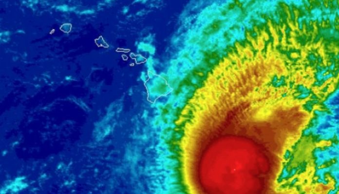
Aug. 2, 2019 (UPI) — While Erick and Flossie are past their peak and are forecast to avoid a direct hit on Hawaii, expect both tropical features to cause more widespread showers and building seas around the islands in the coming days.
While a major disaster is not anticipated, enough rain is likely to fall to interrupt outdoor plans and bring less-than-ideal weather conditions for vacationers over a several-day period. Incidents of flash flooding are likely, especially on the Big Island.
Surf may get too rough for beachgoers and inexperienced boarders. All swimmers and boarders should heed local restrictions. Rip currents will increase in strength and number over the next several days.
Erick is weakening but still brings some risk to Hawaii
Into this weekend, the first system to deliver a glancing blow will be Erick.
Erick is forecast by AccuWeather meteorologists to pass well south of the islands and continue to weaken. Its closest approach to Hawaii will be to the Big Island during Friday morning local time.
“The heaviest rain from Erick will impact the east-facing higher terrain of the Big Island into Friday,” according to AccuWeather Hurricane Expert Dan Kottlowski.
Enough rain can fall on the east-facing slopes to cause flash flooding and mudslides on the Big Island.
Heavier-than-usual showers are expected to spread westward over the islands of Maui, Moloka’i and O’ahu with perhaps a few incidents of urban and small stream flooding into the weekend.
As Erick passes by as a tropical storm, it will cause an initial increase in the trade wind breezes over much of the island chain before breezes diminish or change direction later this weekend.
“Erick has already generated a large swell that will bring rough surf to mostly east- and south-facing coastal areas of the islands,” according to AccuWeather Hurricane Expert Dan Kottlowski.
Late this weekend, there is a chance that Erick turns a bit more to the north and reduces its forward speed after it passes the westernmost islands.
This slowdown and northward drift could generate a light but prolonged southerly breeze of tropical moisture over the islands, especially from Ni’ihau and Kauai to O’ahu.
In this scenario, there is the potential for persistent unsettled conditions and shower activity. This could occur in areas that are typically sheltered from rainfall during the trade winds such as Honolulu and Kekaha.
If Erick maintains forward speed and continues moving more to the west early next week, then conditions are likely to improve over the islands, especially on O’ahu, Kauai, Moloka’i and Maui.
How might Flossie impact the islands?
Meanwhile, Flossie is a few days behind and to the east of Erick over the Pacific Ocean.
AccuWeather meteorologists expect Flossie to take a west to northwest track toward Hawaii into this weekend with an eventual turn more to the north.
How soon that more northward jog occurs may determine the amount of showers from the second wave of moisture and rough surf to affect the islands.
While there is a considerable amount of dry air in between both Erick and Flossie at present, that may change this weekend. Hence, the concern for ongoing wet conditions.
While continuous rain is not expected, there is the potential for a extended period of unsettled weather over much of the island chain as a result of the two tropical systems.
Erick and Flossie won’t be the last tropical systems to affect Hawaii this year.
“The island chain will likely be subject to even more tropical threats in the coming months as AccuWeather meteorologists expect an above-normal hurricane season in the Eastern and Central Pacific,” according to AccuWeather Meteorologist Reneé Duff.


