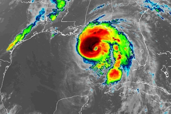
Oct. 10 (UPI) — Hurricane Michael reached Category 4 status Wednesday morning as it heads toward the Florida Panhandle.
In its 2 a.m. advisory, the National Hurricane Center said Michael was an “extremely dangerous” storm with wind speeds of 130 mph. Life-threatening storm surge and heavy rainfall are expected along Florida’s northeastern Gulf Coast.
Michael’s location was about 180 miles south-southwest of Panama City, Fla., and 170 miles southwest of Apalachicola, Fla.
Forecasters say it could bring catastrophic damage when it makes landfall.
“Michael could develop into a potentially catastrophic event for the northeastern Gulf Coast,” the National Weather Service office in Tallahassee, Fla., said. Forecasters said Michael could be the strongest hurricane in 12 years to hit the stretch of coastline from Pensacola to Tampa.
Large waves are expected from Mexico Beach to Keaton Beach, where they could reach 9 to 13 feet in height. Storm surge could reach heights of 6 to 9 feet from the Okaloosa-Walton County line to Mexico Beach and from Keaton Beach to Cedar Key. Cedar Key to Chassahowitzka could see storm surge topping out between 4 to 6 feet. The areas from Chassahowitzka to Anna Maria Island and between the Alabama-Florida border and the Okaloosa-Walton county line could see 2 to 4 feet of storm surge.
“This is a life-threatening situation,” the NHC said Tuesday. “Persons located within these areas should take all necessary actions to protect life and property from rising water and the potential for other dangerous conditions. Promptly follow evacuation and other instructions from local officials.”
“It’s a massive storm,” Florida Gov. Rick Scott said. “We haven’t seen anything like this in the Panhandle in decades.”
Michael was about 220 miles south-southwest of Panama City, Fla., and 200 miles south-southwest of Apalachicola, Fla., the NHC said in an 11 p.m. advisory. The storm was moving north at 12 mph.
A storm surge warning was in effect from the Okaloosa-Walton County line to the Anclote River, the NHC said. A hurricane warning covered the Alabama-Florida border east to the Suwannee River.
The NHC forecasts 4 to 8 inches of rain for the Panhandle, southeast Alabama and parts of southwest and central Georgia. Isolated areas could get 12 inches with the threat of life-threatening flash floods.
Once it reaches land, Michael is forecast to weaken into a tropical storm when it passes through the East Coast, including the New York City area, by Friday morning. The storm’s track will take it back out to the Atlantic Ocean on Friday.
The other storms in the Atlantic Ocean include Tropical Storm Leslie, which returned to hurricane strength. Maximum sustained winds are near 75 mph, the NHC said in an 11 p.m. AST advisory, adding that slow strengthening is forecast during the next few days. The storm was in the central Atlantic Ocean, 1,070 miles west-southwest of the Azores.
Leslie was a subtropical storm on Sept. 23 but weakened into depression, then back into a tropical storm, before reaching hurricane strength again.
Tropical Storm Nadine is also spinning about 495 miles west-southwest of the Cabo Verde Islands, the NHC said at 11 p.m. Tuesday.


