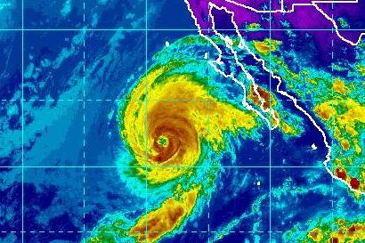
Sept. 30 (UPI) — Hurricane Rosa is preparing to dump rain on northwest Mexico and the U.S. Southwest, the National Hurricane Center said.
The center of the Category 1 storm was 355 miles southwest of Punta Eugenia and 550 miles south-southwest San Felipe, the NHC said in its 5 a.m. PDT update. The storm was moving north at 12 mph and had maximum sustained winds of 105 mph.
Rosa weakened from a Category 4 storm Friday.
A tropical storm warning was in effect for the Pacific coast of the Baja California peninsula from Punta Abreojos to Cabo San Quintin. A tropical storm watch was in effect for the peninsula’s east coast, from Bahia de los Angeles to San Felipe.
Forecasters expected the storm to drop between 3 inches to 6 inches in Baja California and northwestern Sonora with isolated totals up to 10 inches. Two inches to 4 inches could drop in the Mogollon Rim of Arizona and the rest of the desert Southwest, central Rockies and Great Basin could receive 1 inch to 2 inches.
It is expected to make landfall on the western coast of Mexico late Monday or early Tuesday.
“A north-northeastward motion is expected to begin later today and continue through Tuesday. On the forecast track, the center of Rosa will approach the central and northern Baja California peninsula on Monday. Rosa’s remnants will then move quickly across the Desert Southwest on Tuesday,” the NHC said.


