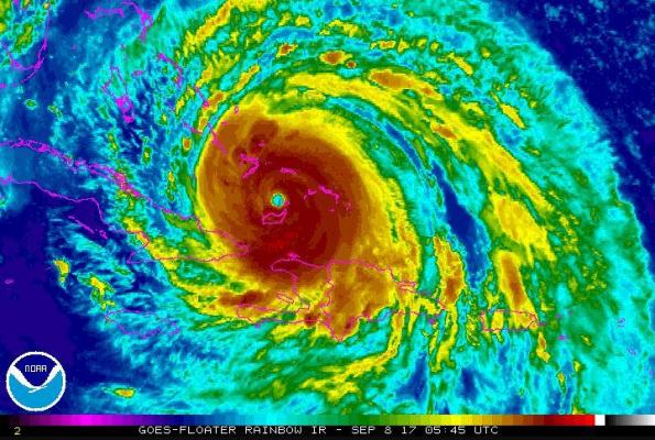
Sept. 8 (UPI) — Hurricane Irma‘s eye was passing just north of Grand Inagua Island as the storm makes its way towards South Florida Friday morning, where a hurricane warning has been issued.
As the storm continues to move toward the continental United States, the National Hurricane Center on Thursday night issued a hurricane warning for South Florida and the Florida Keys. Current path predictions place Irma hitting that region on Sunday.
The NHC said in its 2 a.m. advisory that the storm’s center was about 20 miles east-northeast of Great Inagua Island and 535 miles east-southeast of Miami, Fla. Maximum sustained winds are at 165 mph as it moves at 16 mph.
Irma is still a Category 5 storm and the NHC cautions some gusts are still topping out at more than 160 mph.
“A Storm Surge Warning has been issued from Jupiter Inlet southward around the Florida peninsula to Bonita Beach, as well as for the Florida Keys,” the NHC said. “A Hurricane Warning has been issued from Jupiter Inlet southward around the Florida peninsula to Bonita Beach, as well as for the Florida Keys, Lake Okeechobee and Florida Bay.”
A storm surge watch was issued for the east coast of Florida north of Jupiter Inlet to Sebastian Inlet and for the west coast of Florida north of Bonita Beach to Venice.
On the east coast of Florida, a hurricane watch has been issued north of Jupiter Inlet to Sebastian Inlet, as well as for the west coast of Florida north of Bonita Beach to Anna Maria Island.
In its forecast, the NHC projected Irma’s center would likely reach southeast Florida on Sunday morning. The National Weather Service said parts of South Florida “may be uninhabitable for weeks or months” because of the expected high-speed winds. The weather service expects sustained winds of up to 115 mph to hit the West Palm Beach area, and added that gusts up to 150 mph are possible.
The window for tropical-storm-force winds in the West Palm Beach area is between Saturday afternoon and Monday morning, the National Weather Service said earlier Thursday.
The government of the Dominican Republic discontinued a hurricane warning for the country’s north coast.
Hurricane warnings are in effect for Haiti from the northern border with the Dominican Republic to Le Mole St. Nicholas; Southeastern Bahamas and the Turks and Caicos Islands; Cuban provinces of Camaguey, Ciego de Avila, Sancti Spiritus and Villa Clara; Central Bahamas; and Northwestern Bahamas.
“On the forecast track, the eye of Irma should continue to move near the Turks and Caicos Islands and toward the southeastern Bahamas this evening. The core of the hurricane will then move between the north coast of Cuba and the Bahamas during the next day or two.,” the NHC said at 11 p.m.
Irma’s hurricane-force winds can be felt up to 70 miles from its center. Tropical-storm-force winds extend up to 185 miles from Irma’s center, the NHC said.
Irma’s wind speeds have made it the strongest hurricane in the Atlantic basin, outside the Gulf of Mexico and Caribbean Sea, in the NHC’s recorded history, the center said.


