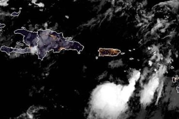
Sept. 24 (UPI) — Tropical storm warnings were issued for Puerto Rico and the United States and British Virgin Islands on Monday as Karen moved northwest through the Caribbean Sea.
Despite weakening from a tropical storm to a tropical depression on Monday afternoon, it could still bring wind tropical-storm-force wind gusts of 39 mph or greater to some areas.
While Karen is forecast to remain weak through the middle of this week, the storm is likely to cause heavy rain over part of the northern Caribbean islands.
AccuWeather meteorologists expect Karen to take a northerly path that will bring the system well northeast of the Turks and Caicos and the Bahamas on Thursday, but not before passing through Puerto Rico and the U.S. and British Virgin Islands on Tuesday.
As of 2 a.m. Tuesday, Tropical Depression Karen was located about 150 miles south of the Puerto Rican capital of San Juan and had maximum sustained winds of 35 mph. It was heading north near 8 mph.
The storm could mean further trouble for the island territory as late Monday, it was rocked by a 6.0-magnitude earthquake, though damages have not been reported and no tsunami warning was issued.
The National Hurricane Center forecast Karen’s center to either pass near or over the island later Tuesday.
Satellite images and aircraft indicate that Karen is poorly organized, with dry air present in a large part of the storm’s weak circulation, as of Tuesday morning.
“The storm has been experiencing strong northeasterly vertical wind shear the past two days and that will continue through Wednesday,” Dan Kottlowski, AccuWeather’s top hurricane expert, said.
As a result “Karen should remain a weak tropical system into the middle of this week,” he added.
However, the system is likely to have enough punch to bring drenching downpours and locally gusty thunderstorms from Puerto Rico to the U.S. and British Virgin Islands into Wednesday. Karen is expected to unleash 2 to 4 inches of rain with isolated amounts of up to 6 inches.
The AccuWeather RealImpact Scale for Karen on these islands and others in the eastern Caribbean is less than one.
The main threats will be from localized flash flooding, mudslides and rockslides on the hilly terrain.
Seas and surf will build as the storm moves northward over the region. Small craft should remain in port and swimmers should be wary of the likelihood of strong and frequent rip currents.
From Thursday into next week, Karen’s path is highly uncertain as steering winds may become weak and erratic.
“Provided high pressure builds north of Karen later this week, the clockwise flow around that high should begin to steer the storm on a more westerly track,” Kottlowski said.
During that time, there is the potential for Karen to become a hurricane.
“As a result of the short-range track and the potential long-range track and strength, interests from Puerto Rico and the Virgin Islands to the Bahamas and Florida should monitor Karen,” Kottlowski said.
Meanwhile, Tropical Depression 13 formed Sunday night just off the coast of Africa. During midday Monday, the depression was upgraded to Tropical Storm Lorenzo.


