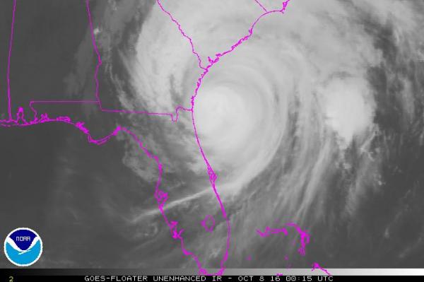
MIAMI, Oct. 7 (UPI) — Still listed as a major hurricane, Matthew continued to swirl up the U.S. East Coast late Friday, packing winds of more than 110 mph.
In its 8 p.m. EDT update, the National Hurricane Center said Matthew, a category 2 hurricane by Friday afternoon, was located about 50 miles northeast of Jacksonville, Florida, and 100 miles east of Savannah, Georgia.
In addition to 110 mph sustained winds, which qualify Matthew as a “major hurricane,” the storm is also bringing heavy rains to the coastlines in north Florida, Georgia and South Carolina. The states will see as many as 12 inches, with isolated areas getting up to 15 inches.
At least four deaths in Florida have been attributed to the storm — two by falling trees, ABC News reported late Friday. More than a million customers are without power.
More than 500,000 Florida residents are still in evacuation zones and 20,000 are being housed in shelters, ABC’s report said.
Forecasters said Matthew will move directly offshore of South Carolina by Saturday afternoon and will likely turn out into the Atlantic Ocean before it can reach North Carolina. It will turn south by Monday and weaken to a tropical storm or depression near the Bahamas and South Florida by Wednesday, the storm’s track shows.
The National Weather Service issued serious warnings to Florida, Georgia and South Carolina residents Friday, putting Matthew in the same league as Katrina as far as potential damage, rain and storm surge are concerned.
Forecasters warned residents along the immediate coasts of “life-threatening inundation” from rain, wind and storm surge in the next 48 hours.
South Carolina Gov. Nikki Haley ordered mass evacuations earlier this week as Matthew approached Florida.
Matthew hit the northwestern Bahamas in the Caribbean on Thursday with powerful 140 mph winds, heavy rain and storm surge of up to 15 feet in some places. More than 250 have been reported killed in Haiti, with the cleanup now beginning to uncover the devastation there.
The NHC also said life-threatening floods could occur along the Southeast U.S. coast by Saturday.
“The combination of a dangerous storm surge and the tide will cause normally dry areas near the coast to be flooded by rising waters moving inland from the shoreline,” the NHC said.
Storm surge was predicted to be 6-9 feet above tide from Flagler Beach, Florida, to Edisto Beach, South Carolina, with amounts elsewhere from 2-6 feet above tide. Those levels will easily inundate many coastal areas in the hurricane’s path.
Matthew is the most powerful Atlantic storm since 2007 and the most powerful hurricane to hit Haiti in 52 years. It made landfall near Les Anglais in southwestern Haiti on Tuesday with 145 mph winds and had destroyed thousands of homes by the time it moved offshore.
Behind Matthew, Tropical Storm Nicole was located 920 miles due east of Miami at 8 p.m. EDT Friday. It had maximum sustained winds of 65 mph and was moving south. It’s expected to turn northwest and pick up speed, possibly hitting Bermuda on Wednesday.


