Dec. 13 (UPI) — Mother Nature is going to be flipping the switch into full-blown winter mode in the Northeast and mid-Atlantic over the coming week as a pair of storm systems are expected to bring rounds of snowfall to the area. The first of which could make for a tricky commute as early as Monday morning.
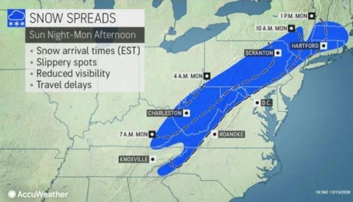
The storm in question for the mid-Atlantic and Northeast is already underway across the south-central United States, bringing snowfall to places like Oklahoma City. Courtesy of very fast jet stream winds well above the Earth’s surface, the storm will quickly race through the Southern states late Sunday and Sunday night, reaching the eastern Ohio Valley and mid-Atlantic states prior to sunrise on Monday.
As the storm treks into the mid-Atlantic and Northeast, travel conditions on portions of interstates 64, 68, 77 and 81, especially across the high terrain and ridge tops of the Appalachians, may feature slick to snow-covered roadways for morning commuters on Monday. Depending on the speed of the storm system, portions of the Pennsylvania Turnpike could even feature a few slick spots prior to noon as well.
Snow will continue to expand northeastward through the day on Monday, tracking across eastern Pennsylvania, upstate New York and even into southern New England. During the daytime hours, temperatures are expected to be just marginally low enough to support snow rather than a chilly rain, so the higher snowfall accumulations may likely be found on non-paved and elevated surfaces.
If temperatures end up being just a few degrees lower than expected, poor road conditions could end up being more widespread along the expected path of the snowfall. On top of that, snowfall totals may end up slightly exceeding the current forecast.
Closer to the coast, places like Philadelphia, New York City and nearly all of New Jersey may have some snowflakes mix in, but temperatures are expected to be just high enough for the primary precipitation type to fall as rain. Again, if temperatures are slightly lower, a quick coating of snow is not completely out of the question.
As temperatures drop through the evening hours on Monday, any remaining untreated roads from West Virginia to eastern Pennsylvania and into southern New England will continue to feature localized slick spots, so we urge any travelers to take it slow in ice and snow. Black ice can also develop in these conditions, so it is best to err on the side of caution if traveling Monday evening.
While this storm will likely not end up being of blockbuster proportions early week, this will serve as a good reminder that it is time to make sure snow blowers are running properly and that it may be time to stock up on de-icing agents like rock salt or sand. If this storm doesn’t require residents to bust out the shovels and snow blowers, another storm that will be brewing by midweek surely will.
The primary impactful weather from this system will come from the snowy side of the storm, but there will also be a round of chilly rain that will traverse the mid-Atlantic and Southeast as well.
The steadiest rain is expected to stretch from the Deep South and Tennessee Valley on Sunday night into the southern Appalachians and Piedmont of the Carolinas and Virginia, as well as the Delmarva Peninsula into the day on Monday.
A fairly widespread swath of 1 to 2 inches of rain is likely, which may lead to localized ponding on roadways and minor flooding in typical flood-prone areas.
The storm system will largely track off the East coast by Monday evening, bringing an end to wet and wintry weather. A brief lull in wet weather is expected on Tuesday before the next winter storm develops by midweek.


