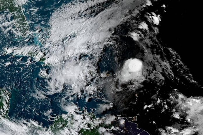
Sept. 21 — Jerry continued its journey to the west on Friday as it neared the Leeward Islands. Jerry, which became a hurricane Thursday, is the 10th named storm and the fourth recognized hurricane of 2019 Atlantic season.
The center of the Category 1 storm is expected to pass just to the north of the Leeward Islands.
In its 8 p.m. update, the National Hurricane Center said the storm’s eye was about 165 miles north-northwest of Barbuda and 125 miles north-northeast of Anguilla. The storm was moving west-northwest at 17 mph with 80 mph maximum sustained winds.
Jerry is no longer expected to strengthen as it did on Tuesday and Wednesday, due to increasing wind shear. Most likely, at least through most of this weekend, Jerry has already peaked in intensity. Jerry spent time as a Category 2 hurricane during Thursday night to Friday morning.
However, the storm’s proximity and intensity prompted parts of the Leeward Islands to issue tropical storm watches, with tropical storm conditions into this weekend.
According to the NHC, the hurricane was packing maximum sustained winds of 80 mph Friday afternoon and was moving west-northwest at 18 mph toward the cluster of islands that includes the U.S. Virgin Islands, the British Virgin Islands, Anguilla, Saint Kitts, Saint Martin, Antigua and Guadeloupe.
“Outer rain bands from Jerry will brush over the northern Leewards, which includes the British and United States Virgin Islands, and Puerto Rico during the next couple of days,” according to AccuWeather Hurricane Expert Dan Kottlowski.
“Winds could gust to near or just over tropical storm force, especially over the higher terrain of these islands. Rain could be briefly heavy bringing a general 1-2 inches,” Kottlowski said.
“However, if a heavier rain band sets up over these islands for a few hours, there could be a locally heavier rainfall amount close to 6 inches. This could cause flash flooding and higher terrain mudslides, he added.
While the projected track of Jerry later in the weekend and next week is one that takes the system over the open waters of the western Atlantic, well to the east of the United States, its progress will have to be monitored. Some indirect impacts on the U.S. are anticipated.
Bermuda could face direct impacts from a possible close encounter with Jerry by the middle of next week, AccuWeather forecasters say.


