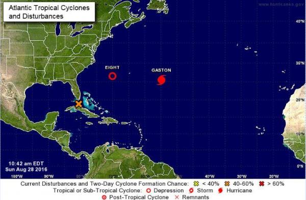
MIAMI, Aug. 28 (UPI) — Tropical Depression Eight formed in the Atlantic Ocean as a disturbance gained strength and Gaston became a hurricane again.
The disturbance, known as Invest 99L, was forecast Sunday by the National Hurricane Center to become the eighth depression of the season but it has been struggling in the past week. The wave now has a 60 percent chance of becoming at least a tropical depression in the next five days. It’s expected to move into the southeastern Gulf of Mexico on Monday, where conditions are more conducive for development. Regardless of development, heavy rainfall and gusty winds are likely in central and northwestern Bahamas, and Cuba through Sunday night.
The tropical weather is about 400 miles southeast of Cape Hatteras, N.C., and is west-southwest of Bermuda, moving 9 mph with maximum sustained winds of 35 mph.
“There is a possibility this may become the first major hurricane of the season if conditions remain conducive into early [this] week,” AccuWeather Meteorologist Ed Vallee said.
Gaston was 600 miles east of Bermuda, moving at 5 mph with maximum sustained winds of 105 mph. Forecasters said further strengthening is possible in the next day or two.
In addition, a tropical wave is expected to move offshore of the west coast of Africa on Tuesday. It has a 60 percent chance of formation over the next five days.
The next hurricane name is Hermine.
In the Pacific, Tropical Storm Madeline was 900 miles east-southeast of Hilo, Hawaii, with maximum sustained winds of 50 mph and was traveling 7 mph northwest, according to the Central Pacific Hurricane Center. It will move near or south of Hawaii by Wednesday or Thursday. The Big Island seems most likely to be impacted by rain and wind.
Also in the Pacific, Hurricane Lester, which was about 950 miles west-southwest of Baja, Calif., was moving westward near 13 mph and maximum sustained winds have decreased to 85 mph. The hurricane is no threat to any land at this time.


