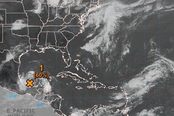
A broad area of unsettled weather located near the west coast of the Yucatan Peninsula will move west-northwestward over the Bay of Campeche this weekend.

This image of the southwestern Gulf of Mexico, taken on Saturday, shows a swirl of clouds in the area of concern. NOAA satellite photo
“Given sufficiently warm water, this low pressure area could evolve into an organized tropical system,” AccuWeather Hurricane Expert Dan Kottlowski said.
There is also relatively low wind shear, or changing of wind speed and/or direction with altitude, over the Bay of Campeche, which provides a conducive environment for tropical features to organize.
However, Kottlowski pointed out that the potential for strengthening may be limited since the feature will remain close to land and over the water for a short time.

Still, strengthening to a tropical depression or even a tropical storm is possible before the low pressure area reaches the east coast of Mexico on Monday into Tuesday.
Should the feature manage to stay offshore and take a more northward track, perhaps paralleling the Mexico and South Texas coast, the chance of development to a tropical storm may be significantly greater.
The next tropical storm that develops in the Atlantic will be called Barry.
Regardless of whether it strengthens into a full-fledged tropical system, heavy rainfall will inundate Mexico into early week.
“This heavy rainfall could lead to life-threatening flash flooding and landslides,” Kottlowski said.
Some of the tropical moisture may be pulled northward into the United States next week.

“There is great concern that torrential downpours associated with the feature, developed or not, may overlap areas that are currently being hit hard by flooding or teetering on the edge of flooding over the South Central states during the first full week of June,” AccuWeather Senior Meteorologist Alex Sosnowski said.
“The moisture from the tropical feature may combine with a non-tropical storm from Texas and Louisiana to parts of Kansas, Missouri, Illinois and Iowa,” Sosnowski said of the situation next week.
Areas of Oklahoma, southeastern Kansas, Missouri, Iowa, Illinois, Louisiana and Arkansas, that were lashed with flooding downpours and severe weather during the second half of May continue to deal with major river flooding.
Subtropical Storm Andrea became the first named storm of the season when it spun up southwest of Bermuda on May 20.
This marked the fifth consecutive year with a named storm in the Atlantic basin before the official start of the season.
The official season lasts from June 1 until Nov. 30.


