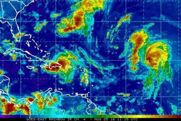
MIAMI, Aug. 25 (UPI) — A tropical wave identified as Invest 99L remains disorganized thanks to strong winds in the upper atmosphere, but it is expected to find more favorable conditions beginning this afternoon as it moves west toward the Bahamas and Florida, according to the National Hurricane Center.
Hurricane Gaston in the mid-Atlantic should weaken into a tropical storm Thursdayas it continues into open water, far from land.
Invest 99L could become a named tropical storm Thursday or Friday as it dumps heavy rains on Puerto Rico and Hispaniola. It is expected to slow down over the Bahamas amid more favorable conditions for growth before approaching Florida. If the weather system becomes an organized cyclone, it will be called Tropical Storm Hermine.
Invest 99L has not formed a well-defined circulation center, which makes forecasting the system difficult. The large tropical wave composed of thunderstorms could reach South Florida by late Sunday. It has a potential of becoming a hurricane.
Whether 99L organizes or not, the National Hurricane Center cautions that its heavy rains and strong winds will still cause problems as it moves west.
“Regardless of development, heavy rains are likely over Puerto Rico today, and strong winds and heavy rainfall are likely over portions of Hispaniola, the Turks and Caicos, and the southeastern and central Bahamas during the next couple of days,” the NHC said in an advisory Thursday morning. “These rains could lead to flash floods and mudslides.”
Better forecasts and tracking models for 99L should be available later Thursdaywhen the storm system is expected to organize into a tropical storm. Hurricane Hunter aircraft have been scheduled to fly through the storm every six hours because of the potential threat to property and residents in South Florida.

Meanwhile, Hurricane Gaston has maximum sustained winds of 75 mph and is about 1,200 miles east of the Leeward Islands headed into the open ocean. It is no threat to land.
“Gaston is moving toward the northwest near 17 mph, and this general motion is expected to continue through Friday. A turn toward the west-northwest is forecast Friday night,” the NHC said in a statement. “Hurricane-force winds extend outward up to 25 miles from the center, and tropical-storm-force winds extend outward up to 90 miles.”
If weakened back to a tropical storm, Gaston is expected to re-strengthen on Saturday and beyond but it is not forecast how much it will re-intensify.


