UTAH, Dec. 21, 2021 (Gephardt Daily) — Another winter storm is heading for the northern part of the Beehive state just in time for Christmas.
“Another winter storm is on tap!” said a tweet from the National Weather Service Salt Lake City. “This one comes in on warm southwest flow with substantial moisture. Northern mountains and the Wasatch Back will see quite a bit of snow, with the majority of precipitation falling as rain elsewhere until cold air arrives Friday.”
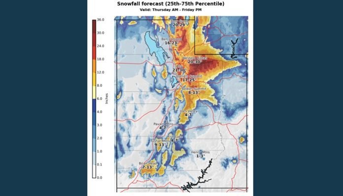
A follow up tweet says: “While uncertainty remains, probabilistic forecasts can help out here! Let’s take a look at the 25th percentile (75% chance of meeting or exceeding this amount) and the 75th percentile (25% chance of meeting or exceeding this amount) to bound a high/low confidence forecast.
“For valley locations, most along the Wasatch Front can expect a trace to 3 inches, while the Wasatch back is carrying ranges from 4 to 9 inches.
A final tweet adds: “As snow lovers, we get excited about higher amounts! While getting more than 30 inches in places from the Thursday-Friday storm is possible, there’s only 25% of the ensemble forecasts supporting that scenario. So, you’re saying there’s a chance..? We’ll keep you up to date.”


