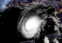
#StaySafe #CityofFortMyers pic.twitter.com/Q5e5V8lkmy
— Fort Myers Police (@fortmyerspolice) September 28, 2022
Sept. 28 (UPI) — Officials in Florida urged residents to take shelter as Hurricane Ian bore down on the southwest coast Wednesday afternoon.
At 1 p.m., the storm was located about 35 miles west-southwest of Fort Myers, moving north-northeast at about 9 mph, with wind gusts of 112 mph were reported at Naples Grande Beach Resort, the National Hurricane Center reported.
“You need to get into the interior of your home and begin to brace for a period of sustained damaging, potentially devastating winds,” Jamie Rhome, acting director of the National Hurricane Center, said, according to the Orlando Sentinel.
“Do not venture outside at all. Do not try to evacuate at this point.”
Kevin Guthrie, director of the state Division of Emergency Management, urged residents not to let down their guard as the eye of the hurricane passes over. He said the I-4 corridor is at high risk of very heavy rain, flash flooding and impassable roads and warned of the dangers of flooded roads, downed powerlines after the storm has passed.
TampaBay Mayor Jane Castor said during a news conference Wednesday morning that the city could still see unprecedented flooding.
“Please don’t let your guard down,” she said.
Gov. Ron DeSantis warned residents who stayed behind to hunker down, saying it was “no longer possible to safely evacuate.”
The track of the storm shifted slightly southeast overnight, putting the eye on track to come ashore sometime Wednesday afternoon near Charlotte Harbor, just north of Fort Myers, with winds of at least 155 mph, which was just shy of a powerful Category 5 storm.
As of 10 a.m. Wednesday, winds had already knocked out power to nearly 200,000 households across the state. Outages were being reported in Lee, Sarasota, Charlotte, Collier counties, as well as along Florida’s East Coast in Palm Beach, Broward, and Miami-Dade.
Officials throughout Southwest Florida have ordered mandatory evacuations of mobile homes, while shelters also remained open for those who decided to ride out the storm.
“Clearly, this is a very powerful major hurricane that’s going to have major impacts, both on impact in southwest Florida, but then as it continues to work through the state,” DeSantis said Wednesday morning for the state Emergency Operations Center in Tallahassee. “It is going to have major, major impacts in terms of wind, in terms of rain, in terms of flooding, so this is going to be a nasty, nasty day – two days.”
At least 2.5 million Floridians were evacuated ahead of the storm, which has been swirling off the Florida coast for hours, with the outer bands already lashing the coast and areas much further inland, and leading to numerous tornadoes.
Local officials throughout the state have already mobilized emergency crews in anticipation of devastation with forecasts calling for extreme wind gusts well above 100 mph.
Officials have also shut down the Sunshine Skyway Bridge across Tampa Bay as a precaution.
The National Hurricane Center said conditions were rapidly deteriorating, with tropical-storm-force winds being felt as far away as 175 miles from the eye of the storm.
Major flooding and strong winds were expected all along the Southwest Florida coast from Tampa Bay to Naples.
Meteorologists said Ian would bring life-threatening conditions, including catastrophic winds and flooding and 12-to-16 foot storm surge from Port Charlotte to Bonita Beach, and all points in between, including Sarasota, Fort Myers, and Estero.
Forecasters say Longboat Key near Bradenton could see 10-foot surge, while Naples – much farther south on the edge of the Everglades – could see an additional 11 feet of water.
Hurricane warnings have been issued in Hillsborough, Lake, Orange, Osceola, Pinellas, Polk, and Seminole counties, while tornado watches cover just about every city across the Florida peninsula.
“If you are in any of those counties, it’s no longer possible to safely evacuate,” DeSantis said. “It’s time to hunker down and prepare for this storm.”


