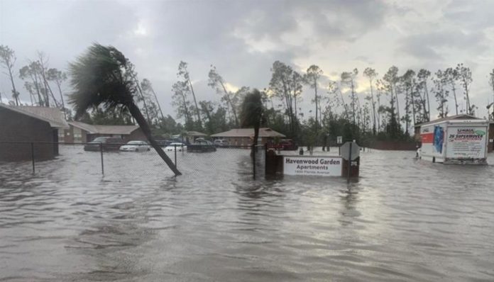
Aug. 17 (UPI) — After making a run in the Caribbean that left thousands without electricity or running water in the Dominican Republic, Tropical Storm Fred trudged onto the shores of the eastern Florida Panhandle Monday.
With maximum sustained winds of 65 miles per hour, just 9 mph below the requirements to be considered a Category 1 hurricane, Fred made landfall near Cape San Blas, Florida, at 2:15 p.m. CDT, according to the National Hurricane Center. It pushed inland at a pace of only 9 mph.
Warm, moist tropical air had resurrected Fred on Monday after the storm had weakened to a depression over the weekend, all but falling apart in terms of how it looked in satellite imagery. But AccuWeather forecasters expected it would restrengthen and it did just that after it emerged over the warm waters of the Gulf of Mexico.
AccuWeather forecasters expect the system to move inland into the Tennessee Valley along the spine of Appalachia.
Florida had at least been preparing for landfall since the previous week when Gov. Ron DeSantis declared a state of emergency for 23 of Florida’s 67 counties. As the storm continued to strengthen upon its approach Monday, tropical storm warnings stretched from Apalachicola to Okaloosa-Walton counties, and school closures extended across the Panhandle.
Storm surge, howling winds and power outages all preceded Tropical Storm Fred, and they continued to build upon landfall. Over 36,000 customers in Florida were without power on Monday evening, according to PowerOutage.US. Nearly half of the electric customers in Franklin County in Florida’s Panhandle were without power by 6 p.m. Monday where winds gusted over 70 mph as Fred made landfall.
Around midday on Monday, Bay County officials had warned residents to expect Fred to be more similar to Sally than to Michael but advised them to stay prepared and stay off the roads nonetheless.
“It’s going to be a nasty afternoon and evening, so just stay home and be safe. We encourage that for the public,” District 5 Bay County Commissioner Philip Griffitts said during the press conference.
Storm surge at Apalachicola, Florida, a coastal city in Franklin County, had reached 4.43 feet above the normal tide level on Monday afternoon. The eyewall of the tropical storm had tracked just west of the city, sending waves crashing over US-98 and high-speed winds tearing through trees.
The scene was similar for other surrounding areas, as rising waters in Indian Pass, Florida, even forced some motorists to leave their cars in the road.
“People could run into a situation where they get stranded when they go through heavy water,” Bay County Sheriff Tommy Ford said. “We ask them not to go through water that’s standing because they don’t know how deep it is. You could end up being in a situation where you’re stranded and need to be rescued.”
In Panama City, multiple streets were flooded as the storm rolled, and traffic lights were also being reported out across the city, according to the Panama City Police Department.
Florida wasn’t the only state to brace for impact, however. Caleb Traugh, a farmer from Early County in southern Georgia, told AccuWeather’s National Reporter Jillian Angeline that direct impacts from tropical systems over four out of the last five years have claimed most of his crops and infrastructure on the farm. He had been hoping this year would be different.
“We certainly don’t mind the rain in reasonable amounts, but the wind is what is catastrophic,” Caleb Traugh told Angeline.
He added that “mother nature and farm economics” have been tough on farmers in southwestern Georgia over the last few years, though this season, with its timely rain, had brought a glimmer of hope.
“This above-average crop has the potential to get many farmers out of a financial hole they have been in for the last several years,” Traugh said. ” …But the sigh of relief only comes after harvest, and we need favorable weather to get us there.”
Fred was the first named storm to break the midsummer lull in the Atlantic hurricane, though that’s not to say it didn’t face any challenges. Many a time Fred lost intensity, dropping as far as a tropical rainstorm before restrengthening into a tropical storm ahead of landfall.
“The reasons why Fred changed intensity several times as it tracked across the Caribbean and the Gulf of Mexico were mainly due to the storm’s interaction with land and wind shear,” AccuWeather Meteorologist Joe Curtis said.
The storm even made the arduous trek through the mountainous terrain of Haiti and the Dominican Republic, which is known as the “hurricane graveyard.”
“As Fred interacted with the mountainous terrain across Hispanola, the mountains greatly disrupted the circulation and convection surrounding the storm, causing it to lose wind intensity,” Curtis said. “Wind shear can also tear apart the storm’s circulation, causing the storm to lose wind intensity.”
As the weakened storm entered the Gulf of Mexico, however, the warm waters replenished the system, allowing it to strengthen and come within 10 mph of hurricane strength.
Two other tropical systems have since populated the Atlantic since Fred’s arrival.
Grace was still clinging to its status as a tropical depression in the eastern Caribbean, skirting the southern shore of the earthquake-ravaged Haiti. Farther east, Tropical Storm Henri emerged on Monday within two hours of Fred making landfall. While the storm is forecast to track near Bermuda, forecasters say that it will likely circle the island rather than run through it.


