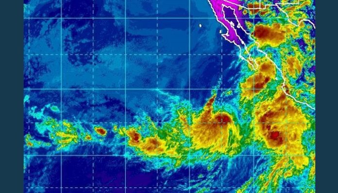
Aug. 23 (UPI) — Ivo is soon expected to become the eastern Pacific Ocean’s next hurricane as it parallels the western coast of Mexico and unleashes dangerous surf into the weekend.
On Wednesday afternoon, an area of disturbed weather off the western coast of Mexico organized and strengthened into Tropical Storm Ivo, the ninth named tropical system this year in the basin.
Ivo continued strengthen Wednesday night and during Thursday morning was packing sustained winds of 60 mph and was tracking west over the Pacific at 13 mph.
The storm remains in an area of warm water and low wind shear, and forecasters expect Ivo to reach hurricane status at any time. It is possible Ivo reaches major Category 3 hurricane status for a while late this week.
“Any strong winds generated by the intensifying tropical system will remain well offshore of Mexico,” AccuWeather Hurricane Expert Dan Kottlowski said.
“With the center of the storm so far offshore, heavy rainfall and mudslides will generally not be directly caused by the storm, but rather a plume of tropical moisture that extends northward well to the east,” According to AccuWeather Senior Meteorologist Rob Miller.
The risk of flash flooding and mudslides will be greatest along the western slopes of the Sierra Madre Occidental Mountains. Those living or vacationing within the states of Colima, Jalisco, Nayarit and part of Sinaloa should keep a watchful eye out for rapidly rising floodwaters and be ready to move to higher ground if necessary.
Motorists are reminded to never attempt to drive through flooded roadways as the water may be deeper than it appears and the road surface underneath could be compromised.
Downpours are forecast to spread into Baja California Sur, including Cabo San Lucas, into Saturday, disrupting beach plans and outdoor activities. Localized flooding may also occur. It is possible that some of this rainfall may be directly associated with Ivo.
“Rough and dangerous surf from Ivo will impact west coastal areas of Mexico, including the southern and western coastal areas of Baja California,” Kottlowski said.
The frequency and intensity of rip currents is also likely to increase. If caught in a rip current, do not panic or fight the current. Swim parallel to the coast until you escape the rip current. You should then swim at an angle, away from the current and toward the beach.
“As Ivo enters colder waters west of Baja California this weekend, it is likely to diminish before reaching waters off the coast of California,” according to AccuWeather Senior Meteorologist Alex Sosnowski.
Even with the storm dissipating, an increase in surf action is likely along the south-facing beaches of Southern California late this weekend and early next week.
“Ivo may also spread some clouds into parts of California early next week,” AccuWeather Meteorologist and western United States blogger Brian Thompson said.
It is possible that a stray shower or thunderstorm will be sparked in the Southern California mountains during this time frame, but unfortunately for the parched Southwest, no meaningful rainfall is expected.
Even with Ivo taking a more northern track than we have seen so far this season, it doesn’t look like it will help to add much fuel to the North American monsoon, according to Thompson.
“With this system being a swing and a miss, there aren’t going to be many opportunities for widespread monsoon thunderstorms through next week,” he added.
Elsewhere in the East Pacific, there are no other areas being monitored in the short term for tropical development. The area of disturbed weather that AccuWeather meteorologists were monitoring for possible impacts to Hawaii next week has fizzled and lost its opportunity to become a tropical storm.


