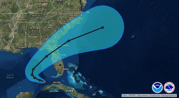
MIAMI, Aug. 29 (UPI) — The tropical weather disturbance that once threatened South Florida has organized into a cyclonic system, now identified as Tropical Depression 9, and is tracking toward Florida’s northern Gulf coast.
Three other weather systems, including Hurricane Gaston in the mid-Atlantic, are also on forecasters’ radar.
Tropical Depression 8, which formed off the coast of North Carolina over the weekend, is heading slowly northwest and expected to turn to the north Tuesday and strengthen into a named tropical storm, the National Hurricane Center said. The storm’s center is forecast to approach the Outer Banks before turning northeast late Tuesday and accelerating toward open water in the North Atlantic.
The storm near North Carolina has maximum sustained winds of 35 mph. A Tropical storm watch is in effect for the Outer Banks from Cape Lookout to Oregon inlet through Tuesday, with a 40 percent to 60 percent chance of tropical storm force winds — up to 39 mph — and higher gusts. Coastal areas in eastern North Carolina can expect 1-3 inches of rain with isolated areas getting up to 5 inches.
Tropical Depression 9 is expected to make landfall north of Tampa, Fla., on Thursday. It has brought isolated heavy rain to South Florida and Cuba, but nothing near the up to 9 inches predicted last week.
Packing maximum winds of 35 mph, the storm was 125 miles west-southwest of Key West, Fla., at 11 a.m. Monday. Moving west at 7 mph, it is forecast to become a named storm Monday night or Tuesday before turning to the north Tuesday night.

Forecasters watched for more than a week as Tropical Depression 9 — then known as Invest 99L — chugged across the Atlantic, north of the Caribbean on a track for Florida and what was forecast to be prime conditions for strengthening into a hurricane. But it tracked slightly farther south than expected, remaining weak due to high level wind shear and interaction with Cuba’s mountains.
Hurricane Gaston is of no immediate threat to land, but could pose major problems for the Azores as a hurricane or tropical storm Saturday and Sunday. As of late Monday morning it was a Category 2 storm packing 110 mph winds with higher gusts, having weakened from a Category 3 storm overnight. It peaked at a reported 120 mph sustained winds late Sunday night.

Meanwhile, a disorganized area of thunderstorms off the coast of south Texas is expected to move slowly onshore Monday or Tuesday without strengthening, but will bring heavy rains and gusty winds to that area before dissipating inland.


