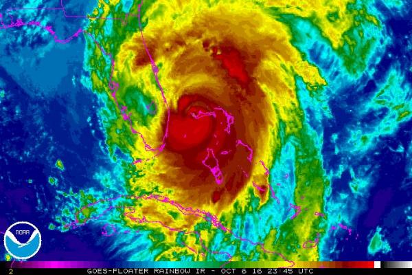
MIAMI, Oct. 6 (UPI) — Hurricane Matthew began moving closer to Florida on Thursday night as it returned to being a Category 4 storm with bands of heavy rains and powerful winds.
The National Weather Service issued serious warnings to Florida residents Thursday night, now putting the storm on par with Katrina in terms of potential damage. At the same time, the National Hurricane Center’s website crashed.
The NWS warned of “extremely dangerous, life-threatening conditions for the next 12 to 24 hours.” It also said “locations may be uninhabitable for weeks or months.”
Matthew hit the northwestern Bahamas on Thursday afternoon with devastating 140 mph winds, heavy rain and storm surge of up to 15 feet in some places. The storm was 75 miles east of West Palm Beach, Florida, moving northwest at 13 mph, the National Hurricane Center reported in its 8 p.m. update.
“The eye of Matthew should move … close to or over the east coast of the Florida peninsula through Friday night,” the NHC said in its Thursday updates, adding that life-threatening floods could occur along the southeast U.S. coast within the next 36 hours, with the worst conditions near the Atlantic.
“The combination of a dangerous storm surge and the tide will cause normally dry areas near the coast to be flooded by rising waters moving inland from the shoreline,” the NHC said.
Storm surge on the Florida coast was expected to be 3 to 5 feet. Surge is much stronger on the storm’s leading right edge, and Florida is fortunate to be on Matthew’s weaker side.
A hurricane warning’s southern line was moved north to reach from Boca Raton, Florida, up to South Santee River, South Carolina. Hurricane warnings also were in effect for the northwestern Bahamas and Florida’s Lake Okeechobee. A tropical storm warning is now in effect from Santee River, South Carolina, to Surf City, North Carolina, as well as from Ocean Reef, Florida, to south of Boca Raton and in the Florida Keys from Seven Mile Bridge eastward, Florida Bay and up Florida’s Gulf coast.
Matthew is now expected to hug the southeast coast up to South Carolina before beginning a loop Saturday afternoon that could bring the storm right back toward the Bahamas and South Florida next week as a tropical storm.
The Bahamas are expected to see total rainfall of 8 to 12 inches, with isolated accumulations of 15 inches, the NHC said. Florida, Georgia and South Carolina coastal areas will likely see rainfall of 4 to 8 inches, with isolated accumulations of up to 12 inches.
Currently, Matthew’s hurricane-force winds extend out 60 miles from the center, and tropical storm-force winds extend out 185 miles.
Matthew is the most powerful Atlantic storm since 2007 and the most powerful hurricane to hit Haiti in 52 years. The hurricane made landfall near Les Anglais in southwestern Haiti at 7 a.m. Tuesday with 145 mph winds and torrential rains. Officials in Haiti now report the death toll there to be 136, with thousands displaced and many homes destroyed.
Officials in Palm Beach County ordered mandatory evacuations in mobile home parks, low-lying areas and some islands.
Broward County Sheriff Scott Israel asked residents to stay at home and off the roads.
Officials in Florida’s Broward, Miami-Dade, Palm Beach, St. Lucie and Martin counties north of the Miami area announced the closure of all schools there Thursday and Friday to prepare for their potential use as shelters. School buses typically do not run in winds stronger than 40 mph.
Meanwhile, Nicole became a hurricane late Thursday afternoon with 85 mph maximum sustained winds in the open Atlantic between Puerto Rico and Bermuda. Nicole is forecast to meander south before turning northwest and picking up speed. It is currently no threat to land.
That would put Nicole and Matthew in relative close proximity, though it’s not clear if the two storms would interact.


