Unusually Powerful Storm Explodes Over Bering Sea
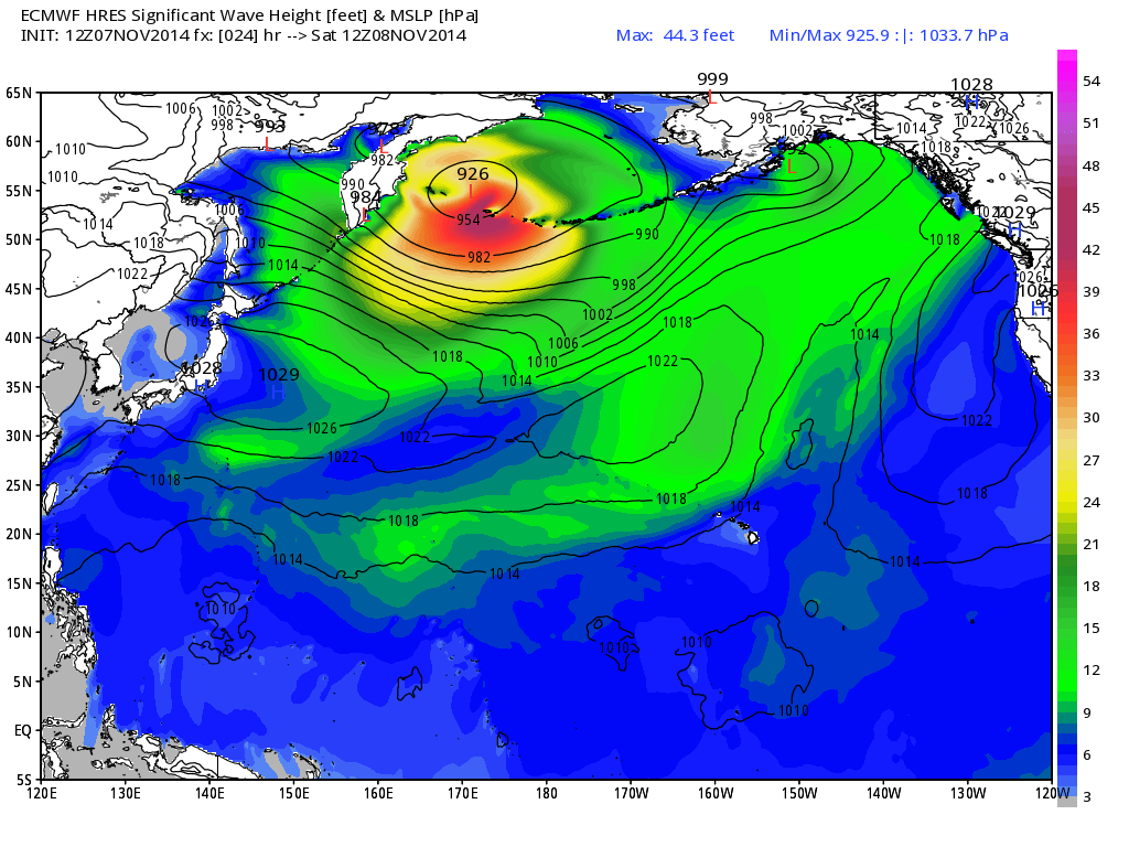
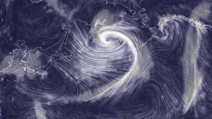
Bombogensis means that the storm’s minimum central air pressure will plunge by at least 24 millibars (mb) in 24 hours, and this storm is going to put that definition to shame, going from about 970 mb on Thursday night to somewhere between 915 and 926 mb within 24 hours. Already, the storm has brought 71-mile-per-hour sustained winds to the Aleutian Island of Shemya, with a gust to 96 miles per hour recorded on Friday morning local time.
“@NWSAnchorage: Wind gust of 96 mph reported at Shemya (PASY), Western Aleutians, #AKwx #Alaska #Nuri #Bering Sea” pic.twitter.com/ukbUQR0RHW
— NWS Alaska Region (@NWSAlaska) November 7, 2014
Hurricane force wind warnings are in effect for the western Aleutians, including Shemya, Attka and Aggatu. Strong winds, high waves and a potentially damaging storm surge is also expected in the more populated Pribilof Islands.
Luckily, the storm is forecast to weaken while still well west of the Alaskan mainland, and it therefore poses little danger to villages on the west coast, let alone population centers such as Anchorage and Juneau.

Computer model forecast for significant wave height and sea level pressure on Nov. 7, 2014.
The Aleutians are sparsely populated, with just a few hundred people in the path of the storm. However, there are military assets at risk, including a missile-detecting radar and airport on Shemya that is used as a refueling location by the military, and by civilian airlines as an emergency landing site for flights across the Pacific Ocean. Shemya is about 1,500 miles southwest of Anchorage, the largest city in Alaska.
MT @shawnmilrad: Crazy RT @davidhulen: Vessels are headed for safety to avoid Bering storm http://t.co/EONmL5bVuN pic.twitter.com/OUVv3Newj5
— 50 Shades of Van (@50ShadesofVan) November 7, 2014
Boats are hurrying to get back to port as the storm churns the sea to wave heights of 50 feet, with peak waves that will be far taller than that.
This storm is the result of the interaction between the remnants of Typhoon Nuri, which at one time was the second-most intense typhoon of the year, with an unusually powerful North Pacific jet stream at upper levels of the atmosphere. Essentially, Nuri is shape-shifting into a different type of powerful storm system, one which draws its energy from differences in air masses, rather than warm ocean waters.
In fact, the boost of energy provided by Nuri is already altering the shape and strength of the jet stream — which is an atmospheric highway that steers storm systems and separates air masses — thousands of miles downstream. With each passing day, computer models have been projecting colder and colder conditions for the Midwest and East Coast during the next one-to-two weeks, and possibly longer, in a pattern eerily reminiscent of some of the polar vortex incursions into the U.S. last winter.
High temperatures in Minneapolis, Minnesota, for example, may be held to below 20 degrees Fahrenheit during the peak of the cold air outbreak late next week, while far colder than average conditions move into the Southeast, Mid-Atlantic and Northeast.
Meanwhile, Alaska and the Canadian Arctic will turn far milder than average, in a phenomenon that some scientists have referred to as the “warm Arctic, cold continents” pattern. This can influence the refreezing of sea ice across the Arctic, and affect Arctic species and native peoples that rely on the ice and snow to hunt and fish.

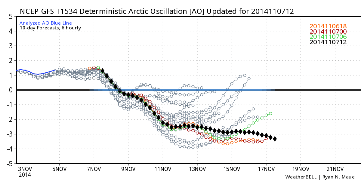
Arctic Oscillation forecast, showing the steep dive into negative territory in one week, as projected by the GFS computer model.
Image: WeatherBell Analytics
As part of the pattern change, the Arctic Oscillation, which is a metric of the pressure difference between the Arctic and the northern midlatitudes, will flip sharply from positive — which favors milder-than-average conditions in the eastern U.S. and Western Europe — to negative.
Computer models on Friday projected that the Arctic Oscillation may approach near record negative territory for this time of year, which is a sign of an extremely cold and possibly snowy period for the central and eastern U.S. The negative phase of the Arctic Oscillation features milder-than-average conditions in the high latitudes, such as Canada and Alaska, and colder and oftentimes snowier-than-average conditions in the eastern U.S. and Western Europe.


