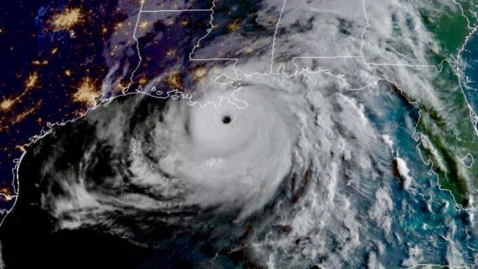
Aug. 27 (UPI) — Hurricane Ida to strengthened rapidly to a Category 4 storm as it neared the coast of Louisiana on Sunday, on the 14th anniversary of the arrival of Hurricane Katrina, forecasters said.
Ida strengthened from a Category 2 to a Category 4 within two hours.
In its 1 a.m. update, the National Hurricane Center said Ida had maximum sustained winds of 105 mph. One hour later it became a Category 3 with 115 mph winds. Then at 2 a.m., it became a “dangerous Category 4 hurricane” with winds of 130 mph.
In the 7 a.m. CDT update, Ida had maximum sustained winds of 150 mph, and was located over the Gulf of Mexico about 50 miles southwest of the mouth of the Mississippi River and 100 miles southeast of Houma, La. Ida was moving northwest at 15 mph.
Hurricanes become a Category 5 when sustained winds reach 157 mph.
Reports from a hurricane hunter aircraft indicate that the maximum sustained winds are near 150 mph with higher gusts.
The NHC said “life-threatening storm surge and hurricane-force winds” are headed to Louisiana.
A hurricane warning is in effect for Intracoastal City, La., to the mouth of the Pearl River, the Lake Pontchartrain, Lake Maurepas and metropolitan New Orleans. Hurricane-force winds extend outward up to 50 miles from the center and tropical storm-force winds outward up to 140 miles.
A tropical storm warning is in effect for Cameron, La., to west of Intracoastal City, mouth of Pearl River to the Alabama/Florida border.
The storm’s motion will continue through late Sunday and early Monday, followed by a slower northward motion.
The NHC said the general motion should continue through Sunday and early Monday, followed by a slower northward motion on Monday afternoon with a northeastward turn forecast by Monday night. Ida is forecast to travel inland over portions of Louisiana and western Mississippi on Monday and Monday night.
“Catastrophic wind damage is likely where the core of Ida moves onshore along the southeast coast of Louisiana,” the NHC said.
Rainfall up to 2 feet are forecast in some area.
“Total rainfall accumulations of 10 to 18 inches with isolated maximum amounts of 24 inches are possible across southeast Louisiana into far southern Mississippi through Monday,” the NHC said. “This is likely to result in life-threatening flash and urban flooding and significant riverine flooding impacts.”
AccuWeather forecasters are warning residents and businesses from the Texas coast to Louisiana and the panhandles of Mississippi, Alabama and Florida, as well as fishing and petroleum operations, to closely monitor the progress of the intensifying storm and heed all warnings and evacuation notices from officials as Ida will strengthen rapidly along its path toward the U.S. Gulf Coast.
“The atmospheric environment is expected to rapidly become more conducive for this system to organize and strengthen,” AccuWeather senior meteorologist Rob Miller said.
Sea-surface temperatures in the northwestern Caribbean and Gulf of Mexico could aid a strengthening storm, as they are well into the 80s F in many areas.
“Not only is there warm surface water along the projected path of Ida, but there is deep warm water in that zone,” AccuWeather chief on-air meteorologist Bernie Rayno said. That can help to counteract any cooling of surface waters that can occur due to the storm’s wave action.
Ida is the fourth storm in the Atlantic basin this year to reach hurricane strength, after Elsa, Grace and Henri. Ana, Bill, Claudette, Danny and Fred maxed out at tropical storm strength. However, Ida would be only the second to become a major hurricane, after Grace.


