Aug. 30 — Hurricane Dorian became a major hurricane on Friday as government officials and residents in the United States and Bahamas continued to prepare for the potentially devastating storm that is forecast to unleash a three-pronged assault of extreme winds, devastating storm surge and severe flooding.
Dorian will make a turn toward the west and continue to strengthen throughout the Labor Day weekend tracking along a path that will take it across the northern Bahamas Sunday and to the Florida coast, perhaps between West Palm Beach and Cape Canaveral, early next week.
More than 20 million Americans face the possibility of feeling impacts from Dorian, including about 3.7 million senior citizens, based on the current forecast.
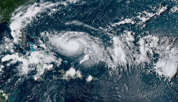
As of 5 p.m. Friday, the National Hurricane Center said the storm’s maximum sustained winds were at 115 mph, which is a Category 3 storm. The storm was located about 420 miles to the east of the northwestern Bahamas and 595 miles west of Palm Beach, Fla. As forecasters predicted, the storm has begun to slow its forward motion, with a current speed of 9 mph, down from 13 mph on Thursday night.
Dorian poses a serious threat to lives and property from the northern Bahamas, Florida and perhaps areas farther north in the southern United States in the coming days.
“Steering mechanisms will weaken while Dorian passes over very warm water with diminishing wind shear this weekend,” according to AccuWeather Hurricane Expert Dan Kottlowski.
As a result, a decrease in the forward speed of Dorian but also significant strengthening are expected with the hurricane likely to reach Category 4 strength on the Saffir-Simpson Scale.
A Category 4 hurricane has sustained winds ranging from 130-156 mph. Some fluctuation in strength is likely once Dorian reaches the Category 4 level.
It is possible that Dorian could pulse to Category 5 strength, which is the highest level of intensity for hurricanes. This is a concern as Dorian travels over deep, warm water of the Gulf Stream where cool, up welled water caused by hurricane wave action is rapidly replaced by more warm water.
Recall that Hurricane Andrew from August 1992 experienced rapid strengthening to a Category 5 over the Gulf Stream prior to making landfall in South Florida.
“Hurricanes often experience eye wall replacement cycles, which can cause the intensity of the core to weaken,” according to AccuWeather Hurricane Expert Dan Kottlowski.
“These are usually brief, but generally unpredictable in advance. However, they do not affect the overall scope of the goings on outside of the eye wall, where tropical storm to major hurricane conditions continue. A decrease to a Category 2 hurricane at landfall can still have a RealImpact of a 4,” Kottlowski said.
Satellite imagery Friday revealed the eye of Dorian becoming more defined and with a core temperature of minus-30 degrees Celsius or minus-22 degrees Fahrenheit. This cold at the top of the storm is a tell-tale sign of strengthening, Kottlowski said.
The strongest winds are in the eye wall with peak gusts to the right of the forward motion of the hurricane.
Winds of Category 4 strength or greater can produce catastrophic damage to poorly constructed homes and buildings. Some roofs can be removed and windows blown out. Widespread power outages occur during Category 4 hurricanes, even well away from the center.
Often spiral bands that extend well away from the center of the storm can produce hurricane-force wind gusts and significant damage.
The exact track, strength and forward speed of the storm will determine which areas are hit the hardest. However, damage and power outages are expected to extend well inland of the coast. This includes areas around Orlando and Tampa.
An overall increase in the size of the storm is expected to continue through landfall in the southeastern U.S. This means that tropical storm and hurricane conditions are likely to extend farther out from the center over time.
Now is the time to prepare your home or business for Dorian’s arrival as tropical-storm-force winds will progress westward ahead of the storm. Installing plywood and storm shutters may be difficult and dangerous once strong wind gusts arrive.
Following a westward path for a three- to four-day stretch, another turn is likely in Florida. That northward turn is what could spread flooding rain, strong winds and coastal flooding in portions of northern Florida, Georgia, South Carolina and North Carolina later next week.
A hurricane watch has been issued for the northwestern Bahamas.
“People on Grand Bahama and Abaco in the Bahamas can expect major damage, widespread power outages and a loss of most other utilities,” Kottlowski said.
“Dangerous flash flooding, as well as storm surge flooding can cause low-lying areas and lower levels of some structures to be submerged for a number of hours,” he added.
Since there is the potential for Dorian’s forward speed to slow to a crawl, locations in its path including the Bahamas, Florida and other parts of the southeastern U.S. may face a prolonged period of storm surge, damaging winds and flooding rainfall.
The most dangerous aspect of a hurricane in terms of lives lost is storm surge.
A storm surge of 10 feet with locally higher levels is forecast near the eye of Dorian over the northern Bahamas and near and to the north of the eye along the Florida coast. The higher storm surge can occur in harbors, back bays, waterways or anyplace where water can get trapped.
People are urged to evacuate if and when such orders have been given. There will likely be a point when crews will not be able to rescue individuals who have decided to stay behind.
Dorian will unleash copious and potentially disastrous amounts of rain.
A general 8-16 inches of rain is forecast along the path of the storm with an AccuWeather Local StormMax of 24 inches. This is based on slow but steady forward motion. However, if Dorian were to crawl or stall, rainfall could be one and a half to two times these amounts.


