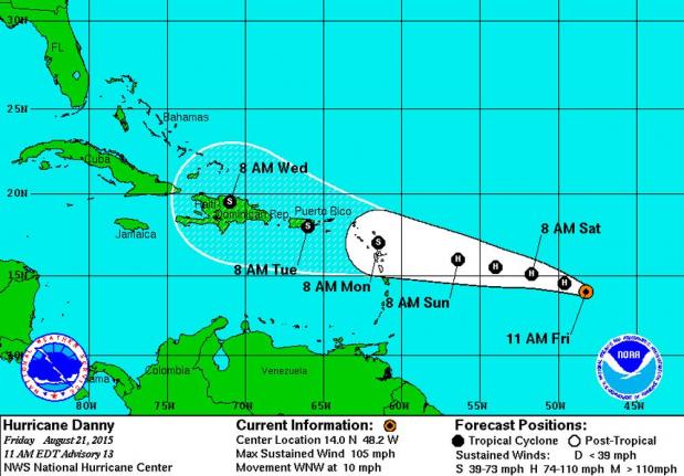
MIAMI, Aug. 21 (UPI) — Hurricane Danny strengthened Friday afternoon to a Category 3 storm with winds of 115 mph as it heads toward the Leeward Islands in the eastern Caribbean.
A new Pacific storm has quickly developed into Tropical Storm Kilo southeast of Hawaii and could affect the state as a hurricane on Wednesday (more information below).
Danny’s eye has become better defined as it has ingested low level moist air to protect itself from dry air that was earlier predicted to weaken it. Forecasters still say Danny will weaken to a tropical storm, moving up that development to its first landfall in the Leeward Islands on Monday. Strong upper-level wind shear in the Caribbean and more dry air are expected to be the source of the weakening.
Danny is projected to track over the northern Leeward Islands as a tropical storm and then Puerto Rico on Tuesday and Hispaniola on Wednesday at the end of the forecast period, remaining a tropical storm with 45 mph winds. Danny would then enter warm open waters of the Atlantic south of the Bahamas, where it could find more favorable conditions with reduced wind shear and less dry air.


Danny’s small size could pose a problem for it as it passes over mountains in Puerto Rico and Hispaniola. It’s a fraction of the size of Typhoon Atsani, a powerful storm that currently poses no threat to land in the Pacific.
A NOAA research plane will investigate Danny Friday afternoon and an Air Force reconnaissance plane will visit the storm on Saturday, each providing new data to better predict Danny’s future. A consensus of long-range models pushes the storm into the Bahamas late next week.

In the Pacific, forecasters are keeping an eye on Tropical Storm Kilo, which has developed quickly and could affect the northern islands of Hawaii as a hurricane on Wednesday. Kilo currently has 40 mph winds and is forecast to become a hurricane on Monday.


