May 26, 2019 (UPI) — It will be no rest for the weary across the central United States as lives and property will continue to be threatened by severe weather and flooding this Memorial Day holiday weekend and into Tuesday.
“The overall weather pattern that has been in place across the U.S. will continue early this week, which will bring more rounds of severe weather to the Plains,” according to AccuWeather Meteorologist Brett Rathbun.
Sunday started with flooding downpours spreading from southeastern Kansas to southwestern Missouri.
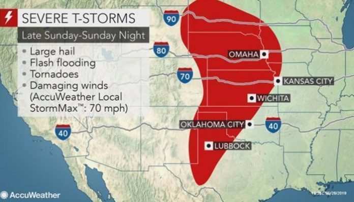
“The main focus of thunderstorms later Sunday into Sunday night will set up from western Texas into the central Plains,” Rathbun said. “The risk may also expand into parts of South Dakota, Wyoming and Montana, which have not received much in the way of severe weather over the past week.”
The severe weather first may initiate across the High Plains late on Sunday afternoon, threatening Tucumcari, N.M; Lubbock and Amarillo, Texas; Lamar, Colo.; Garden City and Colby, Kan.; Sidney, Neb.; and Rapid City, S.D.
The area at greatest risk for devastating tornadoes — EF-2 strength or higher — lies from the northern Texas Panhandle to western Kansas and neighboring parts of Colorado.
There can also be incidents of damaging baseball-sized or greater hail, which can severely injure or kill any person or animal caught outside during the storm.
Motorists planning to travel on stretches of interstates 40 and 70 should remain extremely vigilant and ready to seek shelter. A vehicle is never a safe place to be during a tornado.
The drenching and violent thunderstorms will then race eastward across the central Plains on Sunday night, inundating Wichita, Kan.; Omaha, Neb.a; and Sioux Falls, S.D.
The worst of the severe weather is expected to bypass El Reno, Okla., the site of Saturday night’s deadly tornado. A shower or thunderstorm may still soak the devastated community later Sunday night.
“While the threats for hail, damaging winds and tornadoes will continue for Sunday, flooding is starting to become the most worrisome impact,” Rathbun said. “The central Plains is already dealing with moderate to major flooding from all the rain this month.”
A quick 1-2 inches of rain will easily aggravate flooding from northern Oklahoma to Iowa. In the hardest-hit areas, it may take less than an inch of rain in one to three hours for flooding to worsen.
Adding what falls into Tuesday to totals from this recent week, there can be 12 inches from north-central Oklahoma to eastern Kansas and western Missouri.
“While the threat for severe weather will continue on Monday, the atmosphere is likely to bring a more isolated coverage of storms,” Rathbun said.
Residents should still closely monitor cellphones and weather radios when enjoying Memorial Day picnics, parades and other outdoor activities.
The risk for severe weather on Monday, mainly in the afternoon and at night, will extend along a narrow corridor from the Texas Panhandle to west-central Kansas. The threat zone will also stretch from Nebraska to Iowa and northern Illinois, mainly south of Chicago.
An isolated stronger thunderstorm rumbling over southeastern Wyoming cannot be ruled out.
North of the severe weather, heavy rain threatens to spoil Memorial Day festivities and trigger flooding from southern Minnesota, including Minneapolis to Wisconsin. A separate area of heavy rain with a risk of flooding will develop across eastern Wyoming, Monday into Tuesday.
The severe weather threat across the Plains may ramp up again Tuesday afternoon and night from eastern Nebraska, and southern parts of Minnesota and Wisconsin to Missouri, western Arkansas, Oklahoma and northeastern Texas.
Once again, the communities of Oklahoma City and Tulsa, Okla.; Wichita, Kan.; Omaha, Neb.; Kansas City, Springfield and St. Louis, Mo.; Des Moines, Iowa, and parts of Chicagoland will be at risk.
The threat may also spread northward to Madison, Wis., and southward to Dallas.
All modes of severe weather, including tornadoes, are expected on Tuesday.
The hardest-hit areas of the central Plains may finally welcome much-drier weather Wednesday into Thursday. A part of Oklahoma, Arkansas and northern Texas may have to endure more violent thunderstorms and flooding at midweek before the drier air sweeps in on Thursday.
“However, there are early indications this weather pattern could return next weekend and into the following week with more rounds of severe weather across the central U.S.,” Rathbun said.


