January 5, 2020 (AccuWeather) — A storm tapping into a fresh plunge of cold air will lay a swath of accumulating snow from the upper Ohio Valley to New England from Tuesday into Wednesday.
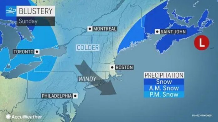
The storm around the middle of next week will follow two rounds of wintry weather in the region, including one during the first half of the weekend.
Late Sunday through Monday, a round of light to moderate snow is likely near and north of Interstate 80, with a general coating to an inch or two expected.
Monday morning commutes around Erie, Pennsylvania, and Buffalo and Syracuse, N.Y., could be slippery.
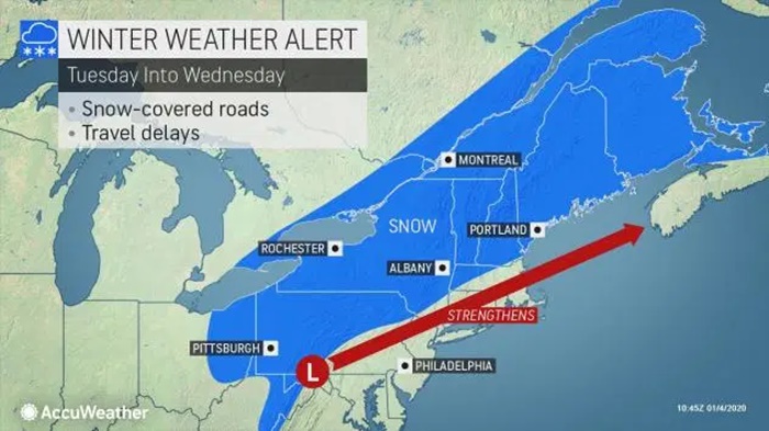
A storm set to form across the lower Ohio Valley on Monday night and swing through the mid-Atlantic and New England from Tuesday into Wednesday will be the next snowmaker in the region.
This storm’s track could allow accumulating snow to fall farther south and east than its two predecessors.
A swath of accumulating snowfall is forecast to extend from a portion of the upper Ohio Valley through the central Appalachians, New York state and New England.
“Parts of interstates 79, 80, 86 and 90 will be impacted Tuesday into Tuesday evening as this quick-moving blast of snow moves through the region,” AccuWeather senior meteorologist Dan Pydynowski said.
“By Wednesday, the steadiest and heaviest of the snow should be confined to Maine and Atlantic Canada as the storm intensifies and moves northeastward,” he added.

Pittsburgh, State College and Scranton, Pa.; Syracuse and Albany, N.Y.; Burlington, Vt.; Manchester, N.H.; Pittsfield and Springfield, Mass.; and Portland and Bangor, Maine, are among some of the communities that could face accumulating snowfall and slippery travel with this event.
There is the potential for a widespread 1 inch to 3 inches of snow with pockets of locally higher amounts from eastern Ohio to Pennsylvania, the mountains of West Virginia and New York state.
Snowfall totals of a 6 inches or more are most likely to occur in New England and Atlantic Canada, where the storm will slow down and intensify.
Portland, Maine, could wind up with yet another heavy snow event, following a December in which the city received nearly double its average monthly snowfall of 13.2 inches.
Mainly rain is forecast for the rest of the major I-95 cities of the Northeast, but any slight shift in the track of the storm could bring snow closer to this corridor.
At this juncture, commuters in the northwestern suburbs of Philadelphia, New York City and Boston will be at greatest risk of experiencing slippery travel late on Tuesday or Wednesday morning.
Areas downwind of the eastern Great Lakes will receive more snow in the storm’s wake as the lake-effect snow machine kicks into high gear.
“Travel could be difficult along the New York State Thruway and I-90 in northwest Pennsylvania as locally heavy snow squalls combine with gusty winds to reduce visibility and make for slippery roadways,” Pydynowski said.
The snow showers and squalls will ramp up as cold, gusty winds rush in behind the storm.
“After a mild start to January, Wednesday will be a wake-up call for many in the mid-Atlantic and Northeast,” Pydynowski said.
“A blast of colder air combined with gusty winds will keep AccuWeather RealFeel Temperatures in the single digits and teens much of the day across interior parts of the Northeast and New England,” he added.
The harsh winds will settle down on Thursday, and conditions are forecast to trend milder by the end of the week as a new storm system approaches from the west.


