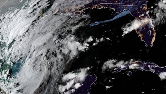
Sept. 18 (UPI) — A disturbance over the Gulf of Mexico that meteorologists have been monitoring for over a week developed into Tropical Depression 22 on Thursday, with maximum sustained winds of 35 mph.
The tropical depression was located about 235 miles east of Tampico, Mexico, 330 miles southeast of the mouth of the Rio Grande and is traveling northeast at just 3 mph, the National Hurricane Center said in its 10 p.m. CDT advisory.
The system could further strengthen into the next named storm of the 2020 Atlantic hurricane season at any time over the next couple of days. The next storm to form will be given the name Wilfred, the last name on the season’s designated list before Greek letters will be used to identify tropical storms.
If the system strengthens further and becomes named, it would become the earliest-21st named storm on record in the Atlantic basin, beating out Vince, which formed on Oct. 8, 2005, according to Philip Klotzbach, a meteorologist at Colorado State University. An unnamed storm identified in post-season analysis of the 2005 season is the reason that Wilfred could break the record of a storm that starts with the letter “V,” Klotzbach said.
Weak steering breezes could result in the budding tropical system to remain nearly stationary or meander over the western Gulf of Mexico over the next few days. It is quite possible that this system could become known as “wandering Wilfred.”
A slow-moving storm such as this can disrupt oil and gas production in the western Gulf of Mexico for several days, AccuWeather meteorologists warned.
But, at some point this weekend to early next week, the system will begin to move. The storm could take a path toward the coast of Mexico or toward the northwestern or central part of the United States Gulf Coast.
“We are getting to the time of the year where it is difficult, due to prevailing steering winds, for tropical systems to move onshore in Texas,” according to AccuWeather’s top hurricane expert, Dan Kottlowski.
“However, we are not fully into that part of the season just yet, and we will have to monitor the behavior of those steering winds and how much an area of high pressure builds across the central and eastern U.S., which could partially block the northward path,” Kottlowski cautioned.
Kottlowski and others at AccuWeather are concerned the system may wander westward toward Texas this weekend.
“How strong the system gets may hold the key as a stronger tropical storm tends to poke higher up into the atmosphere and might get steered westward toward Texas, while a weaker system may hover in the lowest part of the atmosphere, where it avoids the stronger winds aloft and then hovers over the Gulf for days,” Kottlowski said.
As a result, there is a chance the system could wander close enough to Texas to bring heavy rainfall to coastal areas of the state.
There is also the potential for some moisture to be sheared off to the northeast of the budding storm, which could produce heavy rainfall in the Southeast states.
“Any torrential rain could add to the flooding problems from Sally, which are still ramping up as runoff from urban and small streams works into the larger river systems in the Southeast,” AccuWeather meteorologist Courtney Travis said.
“Texas could take a reasonable amount of rain, while areas farther to the east in the South would have trouble,” she added.
Another possibility is that the storm may make several landfalls but never venture far inland, and rather it would spend most of its lifespan over the western Gulf of Mexico and diminish after initially ramping up. In this scenario, the center could bump or brush multiple points of land along a meandering path.
“Gusty winds and rain could reach the south coast of Texas as early as Sunday,” Kottlowski said.
If the system makes landfall as a named storm in the United States, it would be the ninth system to do so this season.
Should the center wander onshore, it could continue to move very slowly or perhaps stall a second time, potentially leading to flooding rainfall on a broad scale.
As the system develops and begins to move northward initially, exact details on the system’s track will become more clear in the coming days, even if it will just prowl around the Gulf for a time.
Regardless of the meandering nature of the storm, there will be substantial coastal impacts. Heavy rain and flooding downpours could frequent coastal areas of the western and central Gulf Coast.
The storm is likely to get large enough and strong enough to create rough seas, pounding surf and dangerous rip currents over the Gulf of Mexico, especially over the central and western Gulf.
There is a 40% chance this system can reach hurricane strength later in the weekend or early next week, forecasters said. All interests along the western and central Gulf coast should monitor the evolution and progress of this system.
Beyond Wilfred, there are several other areas that forecasters are monitoring for tropical development in the Atlantic. Greek letters are likely to be used as AccuWeather meteorologists upped their 2020 season predictions for the number of total storms to 28, which would tie the record number of named storms in the basin set in the notorious 2005 season.


