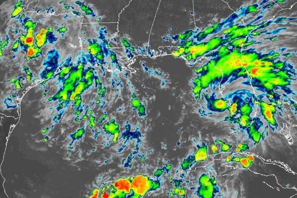
Sept. 4 (UPI) — Tropical Storm Gordon, which pounded southern Florida with heavy rain, is moving toward the Florida-Alabama border, the National Hurricane Center said Monday afternoon.
Gordon strengthened over the course of the day. The storm is now threatening the Florida Panhandle and Gulf Coast with rain, wind and waves.
Forecasters expect the storm to continue to gain strength. By the time Gordon makes landfall along the central Gulf Coast, it is likely to be hurricane.
“A hurricane warning has been issued from the mouth of the Pearl River to the Alabama-Florida border,” the National Hurricane Center announced in a 5:00 p.m. ET update. “This warning replaces the hurricane Watch and tropical storm warning for this area.”
Officials extended the storm surge warning eastward to Dauphin Island, Ala.
Gordon was 50 miles west-southwest of Fort Meyers, Fla.
The storm was moving at 17 mph west-northwest with maximum sustained winds of 50 mph, which is 5 mph higher than the forecast three hours earlier. A weather system becomes a tropical storm when winds reach 39 mph.
The forecast shows the storm system reaching the central Gulf Coast by late Tuesday night and moving inland over the lower Mississippi Valley on Wednesday.
Tropical-storm-force winds extend outward up to 45 miles from the center.
“The tropical storm warning for the upper Florida Keys and from Golden Beach to Chokoloskee, including Florida Bay, has been discontinued,” NHC said.
Gordon is expected to produce rainfall of 2 to 4 inches over the central and northwestern Bahamas, the Florida Keys and South Florida through early Tuesday. Some area in southern Florida may receives 8 inches.
Over southern Alabama, southern Mississippi and Louisiana, rainfall of 4 to 6 inches is forecast. Isolated maximum 8 inches are forecast through early Thursday.


