UPI –The same storm system that brought several rounds of severe weather and flooding rainfall to the south-central United States last week will bring cool, rainy and in some cases snowy weather to the Northeast through early week.
Mother’s Day will turn out to be a washout in much of the mid-Atlantic and southern New England, with rain and drizzle accompanying temperatures more typical of mid-March than the middle of May.
The nicest weather on Mother’s Day can be found across northern New England, where sunshine and dry weather will hold their ground and boost temperatures into the upper 50s to lower 60s.
High temperatures through Tuesday will be no better than the lower 50s in Boston, middle 50s in New York City, upper 50s in Philadelphia and lower 60s in Washington, D.C.
Areas farther inland, from central Pennsylvania to southern parts of Vermont, New Hampshire and Maine, are forecast to have high temperatures stuck in the 40s.
Cloudy, damp, dreary and brisk conditions will cause AccuWeather RealFeel® Temperatures to be stuck in the 40s along the Interstate-95 corridor through Tuesday and in the 30s across interior regions.
A large area of high pressure that originated from northern Canada and that will slide into southeastern Canada for Mother’s Day will drive the cold, Canadian air southward into the Northeast.
“At the same time, a buckle in the jet stream will slow the west-to-east progression of the storm system bringing the soggy weather through early week,” AccuWeather Senior Meteorologist Alex Sosnowski said.
The heaviest rain through Sunday night will extend from the central Appalachians northeastward into the southern mid-Atlantic.
Enough rain can fall to cause street and poor-drainage area flooding, as well as flooding along small streams in a few cases.
“Total rainfall with this storm will average 1-3 inches through Sunday night,” according to AccuWeather Senior Meteorologist Brett Anderson.
There can be an AccuWeather Local StormMax™ of 5 inches in parts of the southwestern Virginia and West Virginia mountains.
Another wave of low pressure will cause more rain to develop on Monday from Pennsylvania and New York into southern and central New England.
An additional 0.50 to 1 inch of rain will be possible from this system, especially across the southern half of New England.
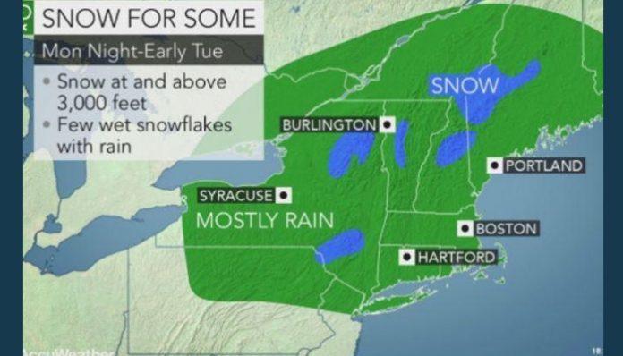
Some of the higher, mountainous terrain in northern New York, Vermont, New Hampshire and Maine, is even forecast to pick up some snow.
While any snow would fail to stick to both paved and grassy surfaces during the daylight hours, it is possible that a slushy inch or two of snow could accumulate at or above 3,000 feet of elevation above sea level from Monday night into Tuesday morning.
In the lower elevations, all rain is expected as temperatures remain too high to support snow.
Although the steadiest precipitation on Tuesday will shift into northern New England, cloudy and showery weather is still forecast to hang on across the rest of the Northeast.
It is not until Tuesday night and Wednesday that dry and more seasonably mild weather will return to the Northeast as the storm system gets kicked farther out to sea.
In the wake of the storm system, Sosnowski warned that there may be the risk of some frost in the normally colder spots where the sky becomes clear on Tuesday and/or Wednesday nights.
Unfortunately, the unsettled weather pattern may return later this week as a battleground zone between lingering cold across eastern Canada and building warmth across the Ohio Valley and mid-Atlantic sets up across the Northeast.
Download the free AccuWeather app to receive flood alerts on your mobile device. Keep checking back for updates on AccuWeather.com and stay tuned to the AccuWeather Network on DirecTV, Frontier and Verizon Fios.


