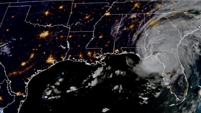
Aug. 30 (UPI) — Hurricane Idalia made landfall in Florida’s Big Bend early Wednesday as a major hurricane.
The National Hurricane Center said in its 8 a.m. EDT update that Idalia had moved inland and was located 10 miles south-southeast of Perry, Fla. It was packing 120-mph winds, making it a Category 3 storm and was moving north-northeast at 18 mph.
Idalia had strengthened into a Category 4 storm early Wednesday but weakened some before making landfall.
Forecasters warned that “catastrophic storm surge and destructive winds” generated by Hurricane Idalia were nearing the Big Bend region of the state.
“A north-northeastward motion is expected through the morning, with Idalia’s center forecast to reach the Big Bend coast of Florida this morning,” it said. “After landfall, Idalia is forecast to turn toward the northeast and east-northeast, moving near or along the coasts of Georgia, South Carolina and North Carolina late today and Thursday.”
The NHC said Idalia should begin to weaken after landfall but is forecast to remain a hurricane while streaking across southern Georgia.
“Idalia should emerge off the southeastern United States coast early on Thursday and move eastward through late week,” it said.
A storm surge warning was in effect for Englewood northward to Indian Pass in Florida, including Tampa Bay, and for St. Catherine’s Sound to South Santee River, while a hurricane warning is in effect for the middle of Longboat Key northward to Indian Pass, including Tampa Bay, and for the east coast of the United States from Altamaha Sound, Ga., to Edisto Beach, S.C.
A tropical storm warning was in effect for Chokoloskee northward to the middle of Longboat Key; west of Indian Pass to Mexico Beach and Sebastian Inlet, Fla., to South Santee River, S.C.; and for north of Surf City, N.C., to the North Carolina/Virginia border; and Pamlico and Albemarle Sounds.
A storm surge watch was in effect for Chokoloskee north to Englewood, including Charlotte Harbor and the mouth of the St. Mary’s River to South Sante River, S.C.
A hurricane watch was in effect for the mouth of St. Mary’s River to Edisto Beach, S.C., while a tropical storm watch was in effect for the lower Florida Keys west of the west end of the Seven Mile Bridge and North of Surf City, N.C., to the North Carolina-Virginia border and for Pamlico and Albemarle Sounds.
The NHC said the combination of dangerous storm surge and the tide will cause dry areas near the coast to flood.
From Wakulla/Jefferson County to Yankeetown in Florida, the water levels could reach as high as 16 feet if the peak surge occurs at the time of high tide, it said, adding that the Ochlockonee River and from Yankeetown to Chassahowitzka could hit 12 feet. Meanwhile, the Chassahowitzka to Anclote River could hit 9 feet.
Portions of Florida’s west coast, the Florida Panhandle, southern Georgia and eastern Carolinas are forecast to receive between 4 and 8 inches of rain between Tuesday and Thursday with isolated higher totals of 12 inches, primarily in the area where the storm makes landfall.
Meanwhile, Hurricane Franklin approaches Florida from the southeast. The NHC says Franklin is expected to reach Bermuda by Wednesday. Its path will then curve along the East Coast.


