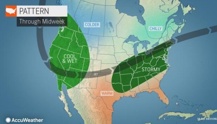
March 22, 2020 (UPI) — An active weather pattern looks to deliver wet weather, and even severe thunderstorms through parts of the country, all before the conclusion of the first week of spring.
A storm that will spread a spring snowstorm from the Midwest into the Northeast through Tuesday, will also be responsible for starting off the train of wet weather in the mid-Atlantic.
“For those looking to take a break from being in their homes by taking a walk around the block or at a neighborhood park, unfortunately, Monday does not look like a good day to do so in much of the Northeast and mid-Atlantic, “said AccuWeather Senior Meteorologist Dan Pydynowski.
“Following the cool spell over the weekend, chilly rainfall will soak the I-95 corridor from Richmond to NYC on Monday,” added Pydynowski.
AccuWeather RealFeel Temperatures on Monday morning will range from the lower 20s in Boston to the lower 30s in Washington, D.C.
After rain moves into the mid-Atlantic Sunday night, it will continue throughout the day on Monday. The dry weather in I-95 corridor of the Northeast will hold until after daybreak on Monday.
Even on the southern side of the storm, rainy weather and thunderstorms may deter residents from heading outdoors on Monday.
The approximate 24 hours of rainy weather will be enough for rainfall to total 0.5 of an inch to 1.0 inch from southern New England to the Deep South. However, there may be some pockets of heavier rainfall following the I-95 corridor from Raleigh to Boston. These areas may see some isolated rainfall totals as high as 2 inches.
Meanwhile, the next storm will be evolving in the central Plains, bringing some showers and thunderstorms from Nebraska to northern Texas by Monday afternoon. Thunderstorms will turn severe across much of this area on Monday night.
“The biggest severe weather threat on Monday will wait until late in the day or nightfall. Storms sweeping through Kansas, Oklahoma and Texas could produce damaging winds as well as hail,” said AccuWeather Meteorologist Tiffany Fortier.
Periods of rain and even some thunderstorms will expand north of this area, affecting Missouri, Nebraska and Iowa Monday night and even into Tuesday.
The core of the severe weather will shift eastward on Tuesday, threatening the southern half of Missouri and much of Arkansas to central Tennessee with more hail and damaging winds.
“The storm will skirt east fairly quickly, moving from being centered over southern Illinois on Tuesday afternoon to the Northeast by Wednesday afternoon,” added Fortier.
This will bring rain and thunderstorms across Tennessee and into the Carolinas, as well as into the Northeast.
Less cold air will be in place across the Northeast come Wednesday, especially compared to the early week storm. Should this pattern hold, most of the region will end up with rain by the middle of the week rather than snow.
Stormy weather looks to continue across much of the country through the latter half of the week and even into next weekend. As with the early part of the week, each region is likely to see at least a 12- to 24-hour break between rounds of wet weather before the next wave moves in.


