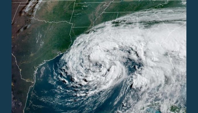
June 7 (UPI) — After Cristobal regained tropical storm status on Friday, the storm gained more strength over warm waters of the Gulf of Mexico into Sunday. The storm has its sights set on the U.S. Gulf coast, where tropical storm and storm surge warnings are in effect.
Not only is Cristobal the earliest third named tropical storm system on record in the Atlantic Basin, the Atlantic National Hurricane Center forecast has it tracking farther west across Wisconsin than any other post-tropical system on record since the mid-1800s.
The National Hurricane Center said in it’s 5 p.m. update that the storm was located about 65 miles south of New Orleans and was moving north at 7 mph. The storm was carrying maximum sustained winds of 50 mph.
A storm surge warning was in effect on Sunday evening from the Mouth of the Mississippi River eastward to Ocean Springs as well as Lake Borgne. A storm surge watch was in effect for East of Mogan City to the mouth of the Mississippi River. A Tropical Storm Warning was in effect for Intracosta City Louisiana to the Okaloosa/Walton County Florida line as well as Lake Pontchartrain and Lake Maurepas.
There is an increased risk for tornadoes in extreme southeastern Louisiana, southern Mississippi and southern Alabama into Sunday afternoon as Cristobal approaches the coast. A tornado watch has been issued for this area through 5 p.m., CDT.
According to AccuWeather Meteorologist Courtney Travis, the potential for a few tornadoes to develop in this region will remain through Sunday night, mainly east of the circulation center of Cristobal.
A plume of tropical moisture associated with Cristobal was fueling showers along portions of the Gulf coast, including along Interstate 10 corridor in the Florida Panhandle and along the western coast of the Sunshine State, on Saturday morning. Cristobal’s outer rain bands were also beginning to reach areas farther west along the central Gulf Coast around New Orleans on Saturday morning. Rain overspread a large part of Florida on Saturday and the balance of the Gulf coast during Saturday night.
As the eastern side of Cristobal swept over Florida, a tornado churned in Sumter County, Fla., near Webster just before 6 p.m. EDT Saturday. A second tornado followed around 6:20 p.m. in Wildwood, Sumter County, destroying a barn, according to the National Weather Service’s Storm Prediction Center.
At 7:30 p.m. EDT, a possible tornado churned up south of downtown Orlando. The storm continued to trigger tornado warnings across Volusia and Seminole counties as the storm moved northward.
An NWS-observed tornado was reported in Orlando around 9:30 p.m. EDT. By the end of the day Saturday, six tornadoes were reported across central Florida.
Cristobal was packing 50 mph sustained winds and was traveling north at 8 mph — down from 12 mph 3 hours earlier — with the center of circulation located 30 miles south-southeast of Grand Isle, La., and about 90 miles south of New Orleans, according to the 2 p.m. EDT advisory by the National Hurricane Center.
A tropical storm warning is in effect for Intracoastal, La., to the Okaloosa/Walton County Florida line as well as Lake Pontchartrain and Lake Maurepas.
Tropical-storm-force winds extend outward up to 205 miles mainly to the east of the center.
The storm is expected to produce total rainfall accumulations of 4 to 8 inches across portions of the central Gulf Coast into the Lower Mississippi Valley, with isolated amounts to 12 inches, according to NWS. Rainfall totals of 2 to 4 inches with local amounts to 6 inches are expected across the eastern Gulf Coast, along with the Mid to Upper Mississippi Valley and Northern Plains near and in advance of Cristobal.
The storm has been designated a 1 on the AccuWeather RealImpact Scale for Hurricanes.
Most of this past week, Cristobal was a tropical depression crawling across southern Mexico and unloading feet of rain in the process.
The worst conditions are skewed to the eastern side of the storm due to winds high in the atmosphere over the Gulf of Mexico.
AccuWeather forecasters expect the system to strengthen further over the warm waters of the Gulf of Mexico before striking the central Gulf Coast late Sunday into early Monday. The central Louisiana coastline is the most likely point of landfall.
“New Orleans can anticipate the greatest impacts from Cristobal through midday on Monday,” stated Travis. “Heavy tropical downpours are likely on-and-off during this time period, and may accumulate as much as 10 inches of rain.
“Into late Sunday night, wind speeds of 50-60 mph are possible in the New Orleans region, with wind gusts as high as 70 mph at the top of taller buildings,” she added.
Ahead of the storm, Louisiana Gov. John Bel Edwards requested President Donald Trump declare a pre-landfall emergency for the state effective Friday.
“We are confident that there will be widespread, heavy rainfall and coastal flooding,” Edwards said in a press release. “I anticipate the need for emergency protective measures, evacuations and sheltering for the high-risk areas … At this time, due to the dangers presented by the COVID-19 pandemic, sheltering activities will need to include non-congregated settings.”
On Sunday, Trump approved an emergency declaration.
He posted on Twitter: At the request of @SenJohnKennedy & @SenBillCassidy of the Great State of Louisiana, I will be approving & signing today an EMERGENCY DECLARATION which will help with all aspects of the big storm that is currently hitting your shores. FEMA is already there. God Bless You!”
Since the system is sprawling in size, and it’s likely to increase in size as it continues to travel over the Gulf of Mexico, impacts from this feature are expected to precede the arrival of the storm’s center by 36 hours to 48 hours, meaning places along the U.S. Gulf Coast could begin experiencing Cristobal’s outer bands well before the storm makes landfall. Scale looks into a broad range of important factors to determine the actual impact the storm will have when it hits land. The scale considers high winds, flooding rain, storm surge and the financial damage and economic impacts. Comparatively, the Saffir-Simpson Hurricane Wind Scale, which has been used by meteorologists for decades, only considers wind speeds.
At this time, AccuWeather forecasters say Cristobal is likely to make landfall in the United States as a tropical storm.
“A combination of increased vertical wind shear and dry air wrapping around the southern and eastern periphery of the storm’s center will restrict just how strong the storm becomes,” Kottlowski said, adding that the risk of Cristobal strengthening to a hurricane prior to landfall will be greatly limited by these two factors.
Wind shear is the increase in wind speed with height in the atmosphere. Low wind shear can aid in tropical storm development and strengthening, but strong wind shear can cause a tropical system to weaken or limit its development.
“However, Cristobal could have maximum-sustained winds just under hurricane force with hurricane-force-wind gusts as it makes landfall,” Kottlowski noted.
Sustained winds of 50 mph to 60 mph are forecast with an AccuWeather Local StormMax of 85 mph near and to the east of where the storm makes comes ashore. However, large spiral bands from the storm can bring strong gusts well away from the center.
Whether storm makes landfall as a tropical storm or a Category 1 hurricane may matter little in terms of impact. A Category 1 hurricane has maximum-sustained winds of 74 mph to 95 mph. A tropical storm can produce maximum-sustained winds of up to 73 mph.
“We do not expect the slow movement of Barry from last year and the 24 inches of rain it delivered along the central Gulf Coast,” Kottlowski said, referring to a short-lived hurricane that struck the Gulf Coast in July 2019 and triggered widespread flooding.


