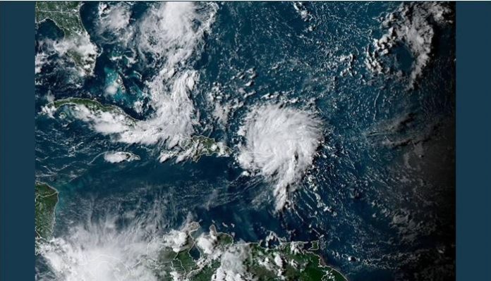
Aug. 28 — Dorian reached hurricane strength on Wednesday, becoming the second hurricane of the Atlantic season.
The newly formed hurricane was packing 80 mph winds as it moved northwest at 14 mph about 45 miles northwest of St. Thomas, the National Hurricane Center said in its 5 p.m. EDT update. As it tracks north of the Bahamas later this week, Dorian is expected to reach Category 3 strength before approaching the southeastern U.S. coast.
The storm made a shift to the north on Wednesday causing its center to regenerate northeast of Puerto Rico and putting forecasters on alert for development of the Atlantic’s first major hurricane of the 2019 season.
The hurricane continued to bring waves of heavy rain to Puerto Rico and parts of the United States and British Virgin Islands on Wednesday after it battered portions of the Lesser Antilles on Tuesday.
Moving into the warm waters of the southern Atlantic will provide the right conditions for Dorian to continue strengthening; AccuWeather meteorologists are forecasting Dorian to intensify into a major hurricane before making landfall as a Category 3 hurricane. Water temperatures in the Atlantic range from from 84 degrees to 86 degrees along the projected path Dorian is expected to take.
“Dorian shifted to the north, and as it traveled over warm open waters, allowing it to undergo rapid strengthening,,” said AccuWeather Hurricane Expert Dan Kottlowski of the storm’s rapid intensification.
The longer the tropical system stalls over the waters of the Atlantic, the longer that Dorian could be a major hurricane.
Interests north and east of the Bahamas should prepare for conditions of a hurricane. Some of the far northern islands of the Bahamas will get significantly impacted while the majority of the others with barely a breeze and a little rain.
A swath of heavy rain, locally damaging winds and battering surf is in store, but the worst conditions are likely to be over a relatively narrow path over open water and across the northern islands of the Bahamas like Grand Bahama and Grand Abaco.
At this time, lesser impacts are expected across the southern half of the Bahamas, farther away from the track of Dorian.
With several days over the open waters of the Atlantic still to go, the exact track of Dorian for the weekend and beyond is not set in stone.
“A very small fluctuation in the overall weather pattern will have a large influence in where Dorian ultimately tracks and how it impacts the continental U.S.,” said AccuWeather Senior Meteorologist Adam Douty.
A weaker high pressure over Bermuda over the weekend or a slower moving low pressure system through opens up locations from the Florida Keys to the Outer Banks for potential impacts.
This could influence whether Dorian tracks westward into Florida or slows before reaching the Florida coast and makes a turn to the north.
“If Dorian does slow and turn to the north, impacts in the Carolinas would be much more significant while Florida would be spared from major damage,” Douty added.
“Because of the wide range of possibilities, the wind, surge and rainfall impacts expected from Dorian over the northern Bahamas and Florida are highly uncertain at this point,” added Kottlowski.
By the time Dorian reaches the United States, the overall size of the storm may be somewhat larger and its impact farther-reaching, when compared to the compact system in the Caribbean. This could bring a wider range of impacts from southern Florida to the Georgia and South Carolina coastline.
As Dorian approaches, conditions will deteriorate first along the southeastern U.S. Atlantic coastlines, with increasingly rough surf and rip currents.
Rainfall will also increase over the Florida Peninsula during the holiday weekend, ahead of landfall sometime late Sunday or early on Monday, depending on how far north the tropical cyclone wanders beforehand.
Heavy, tropical downpours and damaging winds delivered by Dorian will be capable of causing tree and structural damage, as well as power outages.
Once making landfall, should Dorian remain over land, the system may slowly weaken and rain itself out over the southeastern corner of the U.S. through early next week.
However, if Dorian is influenced by other weather systems moving through the eastern U.S., it could be drawn northward along the Eastern Seaboard next week, affecting locations from the coast to the Appalachians.
Dorian could also turn more to the west and reach the Gulf of Mexico, providing another period of strengthening and a wider range of impacts next week. In this case, the overall impacts of the storm on U.S. interests surrounding the Gulf of Mexico will be re-evaluated.


