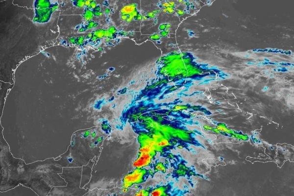
May 25 (UPI) — Forecasters issued tropical storm watches for portions of the United States, Cuba and Mexico on Friday after Subtropical Storm Alberto, the first named storm of the season, formed in the northwestern Caribbean Sea.
The center of the storm was located about 85 miles south-southeast of Cozumel, Mexico, and 195 miles south-southwest of the western tip of Cuba as of the National Hurricane Center’s 5 p.m. EDT update.
Alberto was moving east at 2 mph with 40 mph sustained winds. Forecasters expect Alberto to intensify to a tropical storm Friday evening, but do not anticipate it to become a hurricane.
The NHC issued a tropical storm watch along the eastern coast of the Yucatan Peninsula, from Tulum north to Cabo Catoche in Mexico, in the western Cuban province of Pinar del Rio, from Indian Pass, Fla., west to Grand Isle, La., and Lake Pontchartrain, Lake Maurepas and metropolitan New Orleans in Louisiana. There also was a storm surge watch from Horseshoe Beach, Fla., west to the mouth of the Mississippi River.
“A slow and erratic motion toward the north is expected [Friday night]. From Saturday afternoon into Sunday, a general northward motion at a faster forward speed is expected, followed by a turn toward the northwest on Monday,” the NHC said.
The NHC expects the storm to make landfall late Monday or early Tuesday around the Mississippi or Alabama coast, at which point its strength should decrease and it will become a tropical depression.
The NHC predicted 10 inches to 15 inches of rain with isolated totals of 25 inches in the Yucatan Peninsula and western Cuba.
Rain chances are at 70 percent to 80 percent for portions of Florida throughout the Memorial Day weekend.
South Florida and the Florida peninsula can expect periods of heavy rain and gusty winds, including isolated tornadoes and 3 inches to 7 inches of rain from Friday through Wednesday. Some areas will see up to 12 inches or more.
Flooding was possible in Miami-Dade and Monroe counties after weeks of rain, with tornadoes possible Saturday and Sunday and rip currents expected on both coasts, forecasters said.


