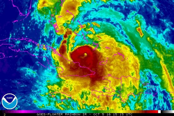
MIAMI, Oct. 5 (UPI) — Hurricane Matthew moved over the Bahamas after pounding eastern Cuba Tuesday night, regaining lost strength as it heads toward Florida, where residents are emptying store shelves and boarding up in preparation for a Category 4 hurricane.
Matthew’s long-range forecast track is showing a dramatic curve away from North and South Carolina, where officials on Monday and Tuesday were bracing for a major hurricane landfall on Sunday and Monday.
At least seven people have been reported killed in the Caribbean, but that number is likely to go higher as the cleanup begins.
The National Hurricane Center reported at 11 a.m. that Matthew was about 105 miles south of Bahamas’ Long Island, picking up speed to 12 mph and heading northwest. Winds strengthened to 120 mph with gusts to 145 mph.
“On this track, Matthew will be moving across the Bahamas through Thursday, and is expected to be very near the east coast of Florida by Thursday evening,” the NHC said.
A hurricane watch has been extended in Florida to Fernandina Beach at the Georgia state line.
A hurricane warning is now in effect on Florida’s Atlantic coast from north of Miami to north of Daytona Beach, with a hurricane watch in place from north of Daytona Beach to the Georgia state line. Also under hurricane warning is Lake Okeechobee north of Everglades National Park, which has closed for the duration of the storm. A hurricane warning remains in place for eastern Cuba and the Bahamas, where Matthew is centered.
Many islands in the Bahamas face inundation as Matthew pushes through, with a storm surge up to 15 feet possible in some locations.
Matthew is now the most powerful Atlantic storm since 2007 and the most powerful hurricane to hit Haiti in 52 years. The hurricane made landfall near Les Anglais in southwestern Haiti at 7 a.m. Tuesday with 145 mph winds and torrential rains. The extent of damage in Haiti isn’t yet clear.
Matthew made landfall in extreme eastern Cuba as a Category 3 storm late Tuesday, bringing life-threatening winds, storm surge and heavy rains.
Officials in Florida’s Broward, Miami-Dade, Palm Beach, St. Lucie and Martin counties north of the Miami area announced the closure of all schools there Thursday and Friday to prepare for their potential use as shelters. School buses typically do not run in winds stronger than 40 mph.
Residents in South Florida began emptying store shelves of bread, water, soda and basic food items Tuesday, and by Tuesday night and Wednesday morning, most stores had only empty shelves. Also sold out were gas cans and full propane cylinders. Some bank ATMs had no cash and many gas stations had run out of fuel. Residents stood for two hours early Tuesday morning, waiting to have propane cylinders filled in Margate, Fla., northwest of Fort Lauderdale.
Meanwhile, another storm formed Tuesday — Tropical Storm Nicole — with 50 mph winds in the open Atlantic between Puerto Rico and Bermuda. Nicole is forecast to head slowly north-northwest toward Bermuda before abruptly turning south on Friday, then west on Friday. Confidence is not high in what the storm will do late in the current forecast and beyond, but it is currently no threat to land.
The NHC warns that time is running out for outdoor preparation for Hurricane Matthew in the Bahamas. Floridians should make preparations as soon as possible, especially those who live on the immediate coast north of Miami.
Forecasters urge everyone in the hurricane watch zone to make final preparations by Wednesday night, because conditions could be too dangerous for outdoor prep and driving after Thursday morning.
President Barack Obama postponed a Hillary Clinton campaign rally at Florida Memorial University near Miami scheduled for Wednesday.
Matthew is forecast to track close to Florida’s Atlantic coast Thursday and Friday as a “major” Category 4 hurricane with winds of 130 mph and gusts to 160 mph, weakening to Category 3 with 110 mph winds as it moves north off Georgia’s coast.
Though Florida will be on the storm’s weakest side as it moves up the coast, residents should expect tropical storm conditions with strong winds and torrential rains beginning as early as Thursday morning.
Long-range forecasts now show the storm making a turn to the north Friday morning while off Daytona Beach, followed by a sharp turn to the east-northeast near Georgia on Saturday and an east-southeast turn on Sunday on its closest approach to North Carolina, well offshore.
Facing strong wind shear on Monday, Matthew is expected to be a Category 1 storm with 80 mph winds. A consensus run of computer hurricane tracking models shows Matthew looping back around south and east again for another go at the Bahamas and Florida, though such long-term predictions are troublesome.
Matthew will drop from 8-12 inches of rain in the Bahamas, with isolated rainfall of 15 inches. Areas in Florida under a tropical storm watch or higher can expect 4-7 inches of rain, with isolated rainfall of 10 inches.
The NHC warns of dangerous flash floods and mudslides in southern and northwestern Haiti, southwestern Dominican Republic and eastern Cuba following recent torrential rainfall.
This is a developing story. Check back throughout the day for the latest updates.


