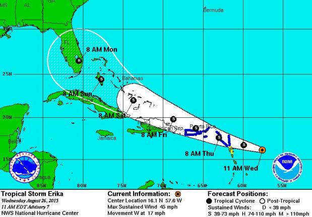
MIAMI, FLORIDA – August 26 (Scott Smith ) — Forecasters continue to track Tropical Storm Erika straight to heavily populated South Florida, where it could be a Category 1 hurricane Monday morning.
National Hurricane Center forecasters remain unsure how strong Erika will become in the short-term, with computer models suggesting the storm either will quickly strengthen or come apart in the next two to three days. Forecasters are taking a middle ground, predicting Erika will slowly strengthen in the next three days and then grow more rapidly in days 4-5 over the Bahamas, reaching hurricane strength with 75 mph winds over the Fort Lauderdale and Miami, Fla., areas at 8 a.m. Monday.
Sustained winds Wednesday afternoon were estimated at 45 mph. Tropical storm warnings are in effect for Puerto Rico, the Virgin Islands, and several other islands in the northeastern Caribbean. It’s forecast to cross the Lesser Antilles Thursday morning, Puerto Rico Thursday night, Hispaniola on Friday and the Bahamas on Saturday.
Erika is looking much more impressive than Hurricane Danny, a tiny storm that blew up into a Category 3 hurricane before quickly dissipating as it encountered wind shear and dry air in the northeast Caribbean. Weather Underground meteorologist Bob Henson says Erika’s large size will help protect it from those limiting factors.
A barrier of strong wind shear in its path and mountains in Puerto Rico and Hispaniola could cause Erika to weaken significantly in the next 72 hours, but if Erika makes it to the Bahamas as a well organized tropical storm, it could intensify rapidly over the warm waters and little wind shear there, Henson said.
Computer models are coming into general agreement for Erika’s path in the next three to five days, which is critical for knowing whether the storm will affect nearly 6 million people living in a thin strip of land from Miami to West Palm Beach, Fla. But NHC forecasters cautioned that their forecast track errors over the past five years are 180 miles at day 4 and 240 miles at day 5. For Erika, that means on Monday it could be anywhere from moving into the Gulf near the Keys to moving into the open Atlantic off Florida’s east coast. The current track takes the middle path, pointing it squarely at South Florida.
The next update on Erika will come late Wednesday afternoon, Eastern time.


