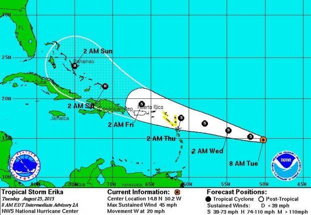
MIAMI, Aug. 25 (UPI) — Tropical Storm Erika formed in the Atlantic Monday night and it’s following a track similar to Hurricane Danny, which has now dissipated into aremnant low pressure system after bringing rains to the Lesser Antilles.
Erika’s winds are estimated at 45 mph and the storm is expected to strengthen as it moves over warmer waters and faces little wind shear, which can tear tropical storms apart, for the next two days.
Computer models early this morning were mixed on Erika’s future, with one predicting it will dissipate in 5 days while others predicting it will become a relatively strong hurricane. The National Hurricane Center follows a middle path between the models, predicting that Erika will become a Category 1 hurricane by Saturday with winds reaching 80 mph on Sunday over the Bahamas and off the east coast of Florida. But because of the models’ divergence, that prediction has a low confidence.
The models also show a range of tracks for Erika, with the NHC putting the storm with a track going over the Lesser Antilles on Thursday, then north of Puerto Rico on Friday and north of Hispaniola on Saturday. A tropical storm watch is already in effect in the northern Lesser Antilles.
Intensity models updated at 8 a.m. on Weather Underground show Erika growing much stronger, approaching 100 mph winds by Monday.

Although hurricane forecasting has advanced in recent years, particularly where storms go, reliable forecasts beyond three days remain elusive.


