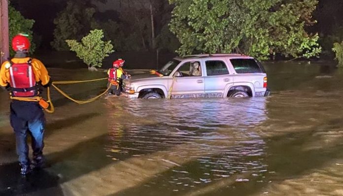
May 22 (UPI) — An onslaught of heavy rain has triggered extensive life-threatening flooding in the southern Appalachians of North Carolina and Virginia, with evacuations underway in the city of Roanoke.
The flood danger prompted the National Weather Service’s Weather Prediction Center to issue a high risk for flooding for Wednesday and Wednesday night, the first time since Feb. 11.
“The same slow-moving storm that caused catastrophic flooding in portions of Michigan early this week will continue to inundate areas in its path into Thursday night,” AccuWeather Meteorologist Brandon Buckingham said.
While Michigan is welcoming much-needed dry weather, the storm shifted toward the southern Appalachians during the middle of the week and is now beginning to wander northeastward.
Through Thursday evening, AccuWeather meteorologists are concerned for a general 4 inches to 8 inches of rain from the storm and widespread flooding from northwestern North Carolina to part of western Virgnia. Similar rain totals and flooding concerns are also expected at the North Carolina beaches. Along the eastern slopes of the southern Appalachians, an AccuWeather Local StormMax of 12 inches can trigger extensive life-threatening flooding.
On Wednesday night, approximately 13 homes were evacuated near Spring Valley Dam in Roanoke, Va., as heavy rain pounded the area.
“Due to heavy rains, the Spring Valley Dam located in the City of Roanoke near Lake Dr. is in danger of failing which could cause flooding in the immediate area of the dam,” a post from the City of Roanoke on Twitter read.
The Roanoke Fire-EMS performed several swift water rescues as floodwaters rose Wednesday night, but no injuries were reported.
“Please be reminded that barricades are in place for a reason. They are there for yours and our protection. #TurnAroundDontDrown,” the agency posted on Twitter.
“This has been a very wet start for 2020 in western North Carolina with many places receiving 6 to 14 inches above normal precipitation,” AccuWeather senior meteorologist Paul Walker said. “Heavy rains through Thursday on already saturated ground will lead to mudslides.”
Mudslides have shut down sections of Interstate 40 through the North Carolina mountains in the past, and that danger is again present this week.
“Boone, North Carolina, has already dealt with a damaging round of flash flooding in late April when over 3 inches of rain fell in a short amount of time,” Buckingham added. With this storm, rainfall totals have already exceeded 4 inches as of early Thursday morning.
In all areas being threatened by the widespread flooding through Thursday, residents should prepare for evacuations as small rivers and streams can quickly rise out of their banks and inundate neighboring land and communities.
Forecasters urge motorists never to drive through a flooded road or bridge to avoid putting yourself and your occupants in danger. It takes only a foot of fast-flowing water to sweep away most cars, and floodwaters can be hide washed out roads and bridges.
“Even in the absence of flooding, the heavy rain may continue to cause travel slowdowns and standing water on major roadways, such as I-77, I-40 and I-26,” AccuWeather senior meteorologist Dan Pydynowski said.
Standing water heightens the risk of vehicles hydroplaning when traveling at highway speeds, and motorists will also be faced with reduced visibility from the downpours and spray from other vehicles.
Even though flooding will prove to be the greatest hazard from the storm, breaks of sunshine could set the stage for isolated severe thunderstorms across the eastern Carolinas and southern Georgia into Thursday evening.
“During the latter part of the week, there should be some relief for cities such as Columbia, South Carolina, as the heaviest rain slowly lifts northward into North Carolina and Virginia,” Pydynowski added.
On Friday, the storm and its rain will press farther north into the mid-Atlantic. By this time, the flood risk will wane with the storm, and the storm will be more of a headache to residents in the mid-Atlantic with disruptions to outdoor plans and travel.
The rain has yet to reach the Chesapeake Bay, but the effects of the storm are already being felt along the bay’s shoreline.
Stiff onshore winds will continue to create rough surf and drive water onshore in the area through Thursday. The coastal flooding may put some areas underneath up to 1 foot of water, potentially leading to road closures and flood damage to homes and vehicles.
As the rain moves into the mid-Atlantic, the risk of flooding may not be over for the Carolinas and southern Virginia.
“Even after the heavy rain ends, there is likely to be a delayed response on the larger rivers,” AccuWeather senior meteorologist Alex Sosnowski said. “It may take until this weekend for moderate to major flooding to occur on the larger rivers as floodwaters drain downstream.”
The Broad, Yadkin, Congaree, Dan and Roanoke rivers are among the waterways that may continue to rise after the heavy rain has ended.
“One of the hardest-hit river basins, in terms of flooding, is likely to be the New River basin, where the focus of the heavy rain has been on Wednesday and will continue into Thursday evening,” Sosnowski said.
Dry weather is not anticipated to follow the inundation of rain through Thursday. Showers and thunderstorms may continue over parts of the southern Appalachians this Memorial Day holiday weekend. Widespread flooding problems are not expected, but any heavy downpours could slow the recession of floodwaters and hinder storm cleanup.


